GPS Telemetry Tags in Animal Movement Research: From Foundational Technology to Advanced Biomedical Applications
This article provides a comprehensive examination of GPS telemetry tags for animal movement tracking, tailored for researchers and scientists.
GPS Telemetry Tags in Animal Movement Research: From Foundational Technology to Advanced Biomedical Applications
Abstract
This article provides a comprehensive examination of GPS telemetry tags for animal movement tracking, tailored for researchers and scientists. It explores the technological evolution from basic tracking to sophisticated, miniaturized transmitters and global satellite networks. The scope covers foundational principles, innovative methodological applications across diverse species, critical analytical frameworks for data interpretation, and comparative validation of tracking methodologies. Special emphasis is placed on how these technologies enable groundbreaking ecological insights and create novel opportunities for biomedical research, including disease vector tracking and behavioral pharmacology models.
The Evolution of Animal Tracking: From GPS Origins to Global Satellite Networks
The expansion of global satellite constellations to over 9,000 active satellites represents a transformative infrastructure for wildlife research, enabling near real-time tracking of animal movements across even the most remote ecosystems [1]. This connectivity backbone supports advanced GPS telemetry tags that transmit finely resolved location data to researchers worldwide, overcoming the historical limitations of data retrieval from inaccessible locations [1]. Modern satellite systems, including established networks like Argos and GPS, alongside emerging constellations from companies like Kinéis and Talos, provide the essential communication link between animal-borne sensors and research institutions [1] [2]. This technological evolution supports a paradigm shift in movement ecology, allowing scientists to monitor animal response to environmental change at unprecedented spatial and temporal scales, which is critical for understanding biodiversity loss, climate change impacts, and disease spread [2].
Satellite Systems and Services: A Comparative Analysis
2.1 Core Satellite Systems Wildlife telemetry utilizes multiple satellite systems, each with distinct operational principles and technological strengths. The Argos system, established in 1978 and operated through collaboration between the French Space Agency, NOAA, and NASA, calculates animal locations using the Doppler effect on signals received by polar-orbiting satellites [3] [4]. The GPS constellation, operated by the U.S. Space Force, comprises 31 satellites that enable tags to compute highly precise location fixes [4]. Emerging systems like Kinéis, a spin-off from the French Space Agency, are deploying a new generation of 25 nanosatellites designed specifically for Internet of Things (IoT) connectivity, offering low-cost, low-energy data transmission from remote areas [1]. The ICARUS 2.0 initiative (a partnership between startup Talos and the Max Planck Society) plans a dedicated cubesat constellation of at least five satellites for high-precision animal tracking, demonstrating the trend toward specialized conservation constellations [2].
2.2 System Performance Characteristics The performance characteristics of satellite systems directly influence research design and data quality. The following table summarizes key operational parameters for major systems used in wildlife tracking:
Table 1: Performance Characteristics of Satellite Systems Used in Wildlife Telemetry
| System | Location Calculation Method | Typical Location Accuracy | Coverage | Primary Data Use |
|---|---|---|---|---|
| Argos | Doppler effect on uplink signals [3] | 250 meters to 4 kilometers [3] [5] | Global, with better coverage at higher latitudes [3] | Long-distance migration, marine species tracking [5] |
| GPS | Satellite trilateration by tag [3] [4] | 5-10 meters (can be centimeter-level with augmentation) [6] | Global [4] | Fine-scale movement ecology, habitat use studies [7] |
| GPS/Satellite Hybrid | GPS calculation with satellite data transmission [3] | 5-10 meters (inherited from GPS) [3] | Global | Near real-time tracking with high precision [3] |
Table 2: Data Transmission Capabilities of Satellite Systems
| System/Technology | Data Transmission Method | Update Frequency | Tag Power Requirements |
|---|---|---|---|
| Argos | Tag transmits to satellite; satellite transmits to ground [3] [4] | 6-28 passes per day depending on latitude [3] | Moderate (transmitter only) |
| GPS Satellite Transmit | Tag transmits stored GPS data via Argos or Iridium [3] | User-programmable (e.g., daily) [5] | High (GPS receiver + transmitter) |
| Iridium | Two-way satellite communication [1] | Higher potential frequency | Higher (two-way communication) |
| Kinéis (Emerging) | Low-power, low-cost satellite uplink [1] | Several times daily [1] | Low (designed for IoT) |
Experimental Protocols for Satellite-Based Wildlife Tracking
3.1 Protocol 1: Tag Selection and Deployment Objective: Select and deploy an appropriate satellite tag to minimize animal impact while achieving research data goals. Materials: Satellite tag, species-appropriate attachment kit (harness, collar, glue, etc.), animal capture and handling equipment, telemetry receiver for tag recovery (optional). Methodology:
- Tag Selection: Choose tag based on animal species, mass, and research questions. Tags must typically be <5% of animal body mass [8]. Key considerations:
- SPOT Tags: For marine animals spending time at surface (sharks, sea turtles, pinnipeds); transmit locations to Argos system when tag is exposed to air [5].
- GPS/Satellite Hybrid Tags: For high-precision tracking of terrestrial species; record GPS locations and transmit via satellite [3].
- Archival Tags: For species where recapture is feasible; store data internally for later retrieval [4].
- Programming: Configure data collection and transmission schedules prior to deployment via manufacturer software (e.g., Wildlife Computers Tag Portal) [5]. Prioritize data transmission to extend battery life for specific seasons or satellite pass times.
- Attachment: Safely capture animal and attach tag using species-appropriate method. Common techniques:
- Release and Monitoring: Release animal and initiate data acquisition via satellite data portal (e.g., Wildlife Computers Data Portal, Argos system) [5].
3.2 Protocol 2: Data Acquisition and Processing Workflow Objective: Establish robust pipeline for acquiring, processing, and validating satellite-derived animal location data. Materials: Computer with internet access, access to relevant data portals (Argos, Wildlife Computers, etc.), data processing software (R, Python, GIS). Methodology:
- Data Reception: Raw location data is automatically delivered from satellite processing centers (e.g., Argos centers in Toulouse, France and Landover, Maryland, USA) to researcher accounts [3].
- Data Filtering: Implement quality control filters to remove erroneous locations using:
- Location Class Filtering: Argos data provides location quality classes (e.g., LC 3,2,1,0,A,B,Z) with estimated accuracy [5].
- Velocity Filters: Remove locations requiring unrealistic movement speeds.
- Spatial Filters: Remove locations outside feasible habitat (e.g., terrestrial points for marine species).
- Data Augmentation: Enhance location data with supplemental sensor information (temperature, depth, acceleration, humidity) collected by modern tags [5] [2].
- Data Integration: Merge telemetry data with environmental layers (sea surface temperature, primary productivity, land cover) in GIS for analysis.
3.3 Protocol 3: System Performance Validation Objective: Field-validate accuracy and reliability of satellite telemetry system. Materials: Test tag, GPS receiver with known high accuracy, open area with clear sky view, data analysis software. Methodology:
- Experimental Setup: Place test tag at known locations surveyed with high-precision GPS.
- Data Collection: Collect satellite-derived locations over extended period (e.g., 2-4 weeks) under varying environmental conditions.
- Accuracy Assessment: Compare satellite-derived locations to known coordinates to quantify:
- Positional Accuracy: Mean and variance of location error.
- Fix Success Rate: Percentage of successful location attempts versus scheduled attempts.
- Environmental Effects: Document effects of habitat, topography, and weather on performance.
- Battery Life Validation: Monitor power consumption against manufacturer specifications under actual transmission patterns.
The following diagram illustrates the complete data flow from animal-borne tag to researcher, highlighting the roles of different satellite constellations:
The Scientist's Toolkit: Essential Research Reagents and Materials
Successful implementation of satellite telemetry requires specialized equipment and software tools. The following table details essential components of the modern wildlife tracking toolkit:
Table 3: Essential Materials for Satellite-Based Wildlife Tracking Research
| Item | Function | Example Specifications/Models |
|---|---|---|
| Satellite Transmitter Tags | Collect and transmit animal location and sensor data via satellite systems. | SPOT tags (Argos transmission) [5], GPS/Satellite hybrid tags [3], ICARUS tags (5g with sensors) [2] |
| Attachment Systems | Securely affix tags to study animals with minimal impact. | Custom-designed collars [7], backpack harnesses [4], fin mounts, transdermal anchors [5] |
| Data Portal Access | Receive, process, manage, and visualize transmitted telemetry data. | Wildlife Computers Data Portal [5], Argos Web Service, Movebank data management platform |
| Programming Interfaces | Configure tag parameters (sampling schedules, transmission priorities). | Wildlife Computers Tag Portal [5], Manufacturer-specific software suites |
| Field Recovery Equipment | Locate and retrieve tags with archival data or for redeployment. | VHF receivers and directional antennas (often integrated into GPS tags) [8] |
| Sensor Modules | Measure environmental and physiological variables. | Temperature sensors, accelerometers, wet/dry sensors, pressure/depth sensors [5] [2] |
| Validation Equipment | Assess system performance and tag accuracy. | High-precision GPS receivers, test stations, calibration tools |
The infrastructure of over 9,000 satellites enables a new era of global connectivity for wildlife tracking, transforming how researchers study animal movement across the planet. By leveraging constellations including GPS, Argos, and emerging systems from Kinéis and ICARUS 2.0, scientists can gather high-resolution movement data in near real-time from virtually any location on Earth. The experimental protocols and toolkit resources detailed in this document provide a framework for implementing robust satellite telemetry studies. As satellite technology continues to evolve toward smaller tags, enhanced sensor capabilities, and dedicated conservation constellations, researchers will gain unprecedented insights into animal behavior, species responses to environmental change, and the ecological connectivity of global ecosystems.
Global Positioning System (GPS) telemetry has revolutionized animal movement tracking research, enabling scientists to remotely monitor the location, behavior, and environmental interactions of wildlife across the globe. These systems provide critical insights into migration patterns, habitat use, and ecological processes, supporting conservation efforts and ecological research [9] [10]. A comprehensive understanding of the core components of these systems—transmitters, networks, and data platforms—is essential for researchers designing tracking studies and interpreting the resulting data. This document details the technical specifications, operational protocols, and system architectures that constitute modern GPS telemetry infrastructure for wildlife research.
Core Components and System Architecture
A GPS telemetry system functions as an integrated technological suite designed to collect, transmit, process, and visualize animal location data. The system's architecture comprises three fundamental subsystems: the transmitter (animal-borne device), the communication network (data transmission pathway), and the data platform (data management and analysis interface). The logical flow of information through these components is illustrated below.
This dataflow is foundational to all GPS telemetry applications. The animal-borne transmitter acquires location coordinates from GPS satellites. This data is then relayed via a communication network to a central data platform, where it is processed, stored, and made accessible to researchers for analysis [11] [9] [12]. In advanced systems, a two-way communication link allows researchers to remotely modify transmitter parameters, such as the frequency of location fixes, based on initial findings or animal behavior [12].
Transmitter Components and Specifications
The transmitter, or tag, is the primary data collection unit deployed on the animal. Its design involves critical trade-offs between device weight, battery longevity, data resolution, and functionality.
Internal Components and Specifications
Modern transmitters integrate several key components into a single, ruggedized package:
- GPS Receiver: Acquires location fixes from satellite constellations. Performance is measured by metrics like Time to First Fix (TTFF), which can be improved with technologies like Quick Fix Pseudoranging (QFP) to as little as 2-5 seconds, conserving battery life [12].
- Battery: The primary constraint on device longevity. Solar panels are increasingly integrated to extend operational life [13]. Battery capacity must be balanced against device weight, especially for small species [14].
- Sensors: Beyond location, modern tags can include tri-axial accelerometers, temperature sensors, magnetometers, and wet/dry sensors, providing rich data on animal behavior and environment [10] [12].
- Memory: Onboard non-volatile flash memory stores sensor data pending transmission. Capacities can exceed 500,000 location fixes [12].
- Communication Module: The hardware (e.g., Iridium, GSM, or Argos modem) that transmits data via the chosen network [9] [12].
Device Types and Comparative Performance
Different research objectives and animal species necessitate different transmitter types. The following table summarizes the primary technologies, their performance characteristics, and ideal use cases.
Table 1: Comparison of Wildlife Tracking Device Technologies
| Device Type | Typical Weight | Location Accuracy | Data Retrieval | Key Advantages | Primary Limitations | Ideal Use Case |
|---|---|---|---|---|---|---|
| GPS with Satellite Uplink (e.g., Iridium) | > 5g [12] | ~2-5m [12] | Remote, global via satellite | Real-time data, global coverage, two-way communication | Heavier, higher cost, requires data plan [12] | Large mammals, long-distance migrants, remote areas |
| GPS with GSM Uplink | Varies | ~2-5m | Remote, via cellular networks | Lower operational cost, high data resolution | Requires cellular coverage [9] | Studies in areas with reliable cell service |
| Platform Transmitter Terminal (PTT) | ~2g and up [14] | ~100-1000m | Remote, via Argos satellite system | Lighter weight, smaller size, global coverage | Lower spatial accuracy, less frequent data [14] | Small to medium birds, long-distance migration studies |
| GPS Data Loggers | < 5g [14] | ~2-5m | Physical recovery of device | Lightest weight, highest accuracy for size, no data plan | Requires recapturing the animal [14] | Small species where recapture is feasible |
| Radio Telemetry | < 5g [14] | Varies with proximity | Manual tracking with receiver | Lightweight, inexpensive, long battery life | Labor-intensive, limited to local scales, no remote data [14] | Small-scale studies, locating nests or dens |
The choice of transmitter is often dictated by the 3-5% rule, which states that the device's weight should not exceed 3-5% of the animal's body mass to minimize impact on its natural behavior [14]. A study comparing GPS collars and solar-powered GPS ear tags on beef cows found significant differences in performance: collars had a mean horizontal error of 2m and 100% fix acquisition, while ear tags had 41m error and only 30.7% fix acquisition during animal testing, the latter driven largely by battery life issues [13].
Communication Networks and Data Retrieval
The communication network is the critical link between the field-based transmitter and the researcher. The selection of a network is a strategic decision based on the study's geographical scope, required data latency, and budget.
Table 2: Comparison of Data Communication Networks for Wildlife Telemetry
| Network Type | Coverage | Data Latency | Bandwidth | Two-Way Communication | Relative Cost |
|---|---|---|---|---|---|
| Satellite (Iridium) | Global [12] | Hours to days [12] | Medium (~70-80 fixes/message) [12] | Yes [12] | High [12] |
| Satellite (Argos) | Global [9] | Days | Low | Limited | High |
| GSM/Cellular | Regional [9] | Near real-time [9] | High | Yes | Low [9] |
| Radio (VHF/UHF) | Local (line-of-sight) | N/A (manual download) | High only upon recovery | No | Low [9] |
| Sigfox/LoRa | Expanding remote areas [9] | Low to moderate | Low | Yes | Low to Moderate [9] |
- Iridium Satellite Network: A system of 66 cross-linked low-earth orbit satellites providing continuous global coverage. Its two-way communication capability allows for confirmation of data receipt and remote reprogramming of field devices, a significant advantage for long-term studies [12].
- Argos System: A scientific satellite system operational since 1978, often used with Platform Transmitter Terminals (PTTs). It is well-suited for tracking long-distance migrations of lighter species, though with lower spatial accuracy than GPS [9] [14].
- GSM/Cellular Networks: Utilize existing mobile phone infrastructure to transmit data via SMS or internet protocols (GPRS). This is a cost-effective solution but is limited to areas with reliable cellular coverage [9].
- Hybrid Systems: Many modern transmitters incorporate multiple technologies. For example, a device may use Iridium for primary data transfer but also include a VHF transmitter to aid in the final physical recovery of the animal or the unit itself [12].
Data Platforms and Analytical Frameworks
Once transmitted, data is processed, stored, and analyzed through specialized software platforms. These platforms transform raw data streams into actionable biological insights.
Core Platform Functions
- Data Processing and Management: Raw data from transmitters is decoded, filtered for erroneous fixes, and formatted. Platforms like Movebank, which holds over seven billion sensor records across 1,400 species, serve as massive, centralized repositories for wildlife tracking data [10].
- Visualization and Analysis: Geographic Information System (GIS) software and custom tools (e.g., GRASS, Google Earth) allow researchers to plot animal movements on maps, calculate home ranges, and identify movement corridors [9].
- Integration with Environmental Data: A key advancement of platforms like the Internet of Animals is the integration of animal movement data with satellite-derived environmental data, such as vegetation changes, surface water depth, and land use. This enables researchers to understand why animals move in response to environmental conditions [10].
- Predictive Modeling: Combined telemetry and environmental data feed into statistical models in platforms like R, allowing scientists to predict animal distribution under future climate scenarios or assess disease transmission risks, such as avian influenza spread by waterfowl [9] [10].
The workflow for handling data from acquisition to publication is methodical and iterative, as shown in the following protocol.
Experimental Protocols for System Deployment
A successful GPS telemetry study requires meticulous planning and execution across three phases: pre-deployment, field deployment, and post-deployment data management.
Pre-Deployment Planning and Device Configuration
Objective: To define research questions and select/configure appropriate technology. Protocol:
- Define Biological Questions: Clearly articulate the study's goals (e.g., "Determine the migration routes and stopover sites of the Eastern Curlew.").
- Select and Configure Transmitters:
- Choose device type and attachment method based on species morphology and behavior (see Table 1).
- Use manufacturer software (e.g., Telonics Product Programmer - TPP) to program duty cycles. Balance fix frequency (e.g., 4-8 fixes/day for migration studies) against battery life estimates [12].
- For testing, configure geofencing alerts to notify researchers if an animal enters or leaves a predefined area [12].
- Ethical and Welfare Review: Secure approval from institutional animal care and use committees. Adhere to the 3-5% body weight rule for device mass [14].
Field Deployment and Animal Tagging
Objective: To safely capture animals and deploy transmitters with minimal impact. Protocol:
- Capture: Use species-appropriate, safe capture techniques (e.g., mist nets for birds, cage traps for mammals) by trained personnel.
- Attachment:
- Collars: Used for mammals where the head is larger than the neck (e.g., primates, large cats) [9].
- Harnesses: Used for animals where neck diameter exceeds head size (e.g., pigs, Tasmanian devils) or for large birds [9].
- Leg-loop Harnesses: For shorebirds, use soft, degradable materials (e.g., elastic) to minimize long-term impacts [14].
- Direct Attachment: For birds, reptiles, and marine mammals, devices are glued to feathers, skin, or carapace, and are designed to fall off during molting [9].
- Data Verification: Before release, confirm the device is powered on and has acquired a GPS fix.
Post-Deployment Data Management and Analysis
Objective: To process, analyze, and interpret transmitted data. Protocol:
- Data Retrieval: Automate data flow from the communication network (e.g., Iridium) to a designated data platform (e.g., Movebank) [10] [12].
- Data Cleaning: Filter location data based on dilution of precision (DOP) values, fix dimensions (2D/3D), and movement speed to remove implausible locations.
- Data Analysis:
- Use GIS software to visualize movement paths and calculate metrics like daily distance traveled and home range size (e.g., using kernel density estimation) [9].
- Apply movement models (e.g., in R package
moveHMM) to identify behavioral states (e.g., foraging, migrating, resting) from GPS and accelerometer data [9] [10]. - Integrate location data with remote sensing layers (e.g., NDVI for vegetation, land cover class) to assess habitat selection [10].
The Scientist's Toolkit: Essential Research Reagents and Materials
The following table details key materials and software solutions essential for conducting GPS telemetry research.
Table 3: Essential Research Reagents and Solutions for GPS Telemetry Studies
| Item Name | Function/Application | Example Specifications/Notes |
|---|---|---|
| GPS/Iridium Transmitter | Collects and remotely transmits high-resolution location data globally. | E.g., Telonics TGAV-4270-5: Weight: 140g, Memory: ~500K fixes, Iridium two-way communication for remote programming [12]. |
| Platform Transmitter Terminal (PTT) | Tracks long-distance migration of smaller species via Doppler shift. | Weight: ~2-5g, Uses Argos satellite system, lower spatial accuracy than GPS, suitable for birds under 200g [14]. |
| GPS Data Logger | Stores high-accuracy location data internally for later retrieval. | Weight: <5g, No data transmission cost, requires animal recapture, highest accuracy-to-weight ratio [14]. |
| VHF Transmitter & Receiver | Enables short-range, ground-based tracking and device recovery. | Used as a backup to satellite systems; essential for locating animals in dense habitat or recovering data loggers [12]. |
| Attachment Materials | Secures the transmitter to the animal with minimal welfare impact. | Includes collar material, harnesses (e.g., leg-loop made from degradable elastic), and non-toxic epoxy for direct attachment [9] [14]. |
| Movebank Platform | A free online platform for managing, sharing, analyzing, and archiving animal movement data. | Hosts billions of data points; allows integration with environmental data from NASA and other remote sensing sources [10]. |
| Telonics Product Programmer (TPP) | Software for programming, estimating battery life, and sending remote commands to compatible transmitters. | Allows customization of GPS fix schedules, VHF pulses, and Iridium transmission intervals [12]. |
| R Statistical Software | Open-source platform for statistical computing and graphics, essential for advanced movement analysis. | Used with specialized packages (e.g., move, amt, moveHMM) for analyzing trajectories, habitat selection, and behavioral states [9]. |
Application Notes
The development and deployment of the BlūMorpho transmitter, a 60-milligram, solar-powered radio tag, represents a pivotal advancement in wildlife telemetry [15] [16]. This miniaturization breakthrough enables high-resolution tracking of small, migratory insects like the monarch butterfly (Danaus plexippus), a species previously unsuitable for individual long-distance telemetry studies due to its low body mass (typically under a gram) [15].
The technology's application within Project Monarch, a large-scale collaborative effort, has successfully provided the first near-real-time, individual-level data on the complete monarch migration from Canada to their overwintering sites in central Mexico [15] [17]. The transmitters operate at 2.4 GHz (Bluetooth frequency), allowing their signals to be detected not only by dedicated wildlife receiver networks (e.g., Motus) but also by millions of standard smartphones running the dedicated Project Monarch app, creating a massive, crowd-sourced detection network [15] [16].
Table 1: Key Performance Data from the 2025 Project Monarch Tracking Season
| Metric | Value | Context / Source |
|---|---|---|
| Transmitter Mass | 60 mg | Ultralight, solar-powered [15] [16] |
| Total Transmitters Deployed | >400 | Deployed across North America and the Caribbean [15] |
| Partner Organizations | >20 | Cross-institutional collaboration [15] [17] |
| Sample Success Rate (Monarch Watch) | 30% (9 of 30) | Proportion of tagged monarchs detected in Mexico [17] |
| Detection Range Enhancement | Continental scale | Leveraged dedicated receivers and crowd-sourced smartphone networks [15] |
Research Context and Significance
This technology directly addresses a core limitation in movement ecology: obtaining high-resolution spatiotemporal data from small-bodied animals [18]. Prior to this, monarch migration studies relied on mark-recapture using physical sticker tags, which provide only two data points—release and (if fortunate) recovery [17]. The BlūMorpho transmitter reveals the entire journey, capturing fine-scale movements, routes, stopovers, and responses to environmental conditions like wind, as demonstrated by the detailed track of monarch "MW026" [17].
The data fidelity is sufficient to observe that migration progress can be significantly slowed by unfavorable southern winds, a level of ecological insight previously unattainable [17]. Preliminary results from the 2025 season suggest that the success rate of tagged monarchs reaching Mexico may exceed previous population-level estimates, opening new avenues for researching migration survivorship [17].
Experimental Protocols
The following protocol outlines the methodology for deploying BlūMorpho transmitters and collecting tracking data, as utilized by the Project Monarch collaboration in the fall 2025 season [15] [17].
Pre-Deployment: Transmitter Activation and Ethical Considerations
- Transmitter Check: Verify that the BlūMorpho transmitter is functional and charging via its integrated solar panel under light exposure [15].
- Ethical Review and Permitting: Secure all necessary permits from relevant wildlife and conservation authorities for the capture, handling, and tagging of monarch butterflies [19]. The project adhered to standardized protocols reviewed by collaborating institutions [15].
- Animal Welfare Assessment: Prior to deployment, researchers should justify that the scientific objectives outweigh the potential impact on the individual. Research from James Madison University integrated into the project concluded that survival was unlikely to be impacted in properly tagged individuals [15].
Field Deployment: Capture and Tagging
Table 2: Research Reagent Solutions and Essential Materials
| Item | Function | Specification / Note |
|---|---|---|
| BlūMorpho Transmitter | Emits a unique RF signal for individual identification | 60 mg, 2.4 GHz, solar-powered [15] [16] |
| Adhesive | Affixes transmitter to the butterfly | Hypo-allergenic, non-toxic, quick-setting formula |
| Fine-point Forceps | For precise handling during tag attachment | - |
| Butterfly Net | For safe capture of wild monarchs | - |
| Project Monarch App | Installed on smartphone to act as a passive receiver | Available on iOS and Android [15] |
- Capture: Using a butterfly net, safely capture a wild, migrating monarch butterfly.
- Handling: Gently handle the butterfly to minimize stress. The species is resilient to brief handling periods.
- Tag Attachment: Using fine-point forceps, apply a small, minimal amount of safe adhesive to the base of the transmitter. Carefully affix the transmitter to the butterfly's dorsal thorax, ensuring the solar panel is unobstructed and the insect's movement is not impeded. The entire attachment process should be completed in under two minutes.
- Release: Release the tagged monarch at the site of capture and record the precise release coordinates, date, and time.
Data Collection and Processing Workflow
The data collection leverages a multi-modal network, and the subsequent processing converts raw signals into reliable location estimates. The workflow can be visualized as follows:
Figure 1: Workflow for wildlife tracking data acquisition and processing.
- Signal Detection: The transmitter's signal is passively detected by a network of receivers [15]. This network includes:
- Data Transmission: Raw detection data, including Received Signal Strength (RSS), timestamp, and transmitter ID, are uploaded to a central data portal (e.g., the BlūMorpho Portal) [15].
- Location Estimation: A grid search algorithm is recommended for converting RSS data into accurate location estimates [18]. This method involves:
- Model Fitting: Prior to analysis, an exponentially decaying function (S(d) = A - B exp(-C d)) is fitted to empirical data characterizing the relationship between RSS and distance for the specific transmitter-receiver system [18].
- Grid Calculation: The study area is divided into a fine-scale grid. For each grid cell, the algorithm calculates the distance to every receiver that detected the signal [18].
- Likelihood Scoring: A criterion function (e.g., a normalized sum of squared differences) compares the measured RSS values from all receivers with the values predicted by the RSS-distance model for that grid cell. The cell with the lowest score (best fit) is the most likely location of the transmitter [18]. This method has been shown to be more than twice as accurate as traditional multilateration, especially in receiver networks with wide spacing [18].
- Data Cleaning and Error Checking: Implement an automated data cleaning pipeline to identify and flag biologically implausible locations resulting from signal noise or other errors [20] [21]. This involves:
- Analysis and Visualization: The cleaned, high-resolution tracking data can be analyzed for movement metrics (speed, direction, stopover duration) and visualized in the Project Monarch Science app or other GIS software to reveal migration paths and individual behaviors [15] [17].
The study of animal movement has been revolutionized by advances in GPS telemetry and biologging, enabling researchers to track everything from livestock to elusive wildlife across the globe. These technologies provide critical data on migration, behavior, and habitat use, which directly informs conservation strategies, livestock management, and ecological research.
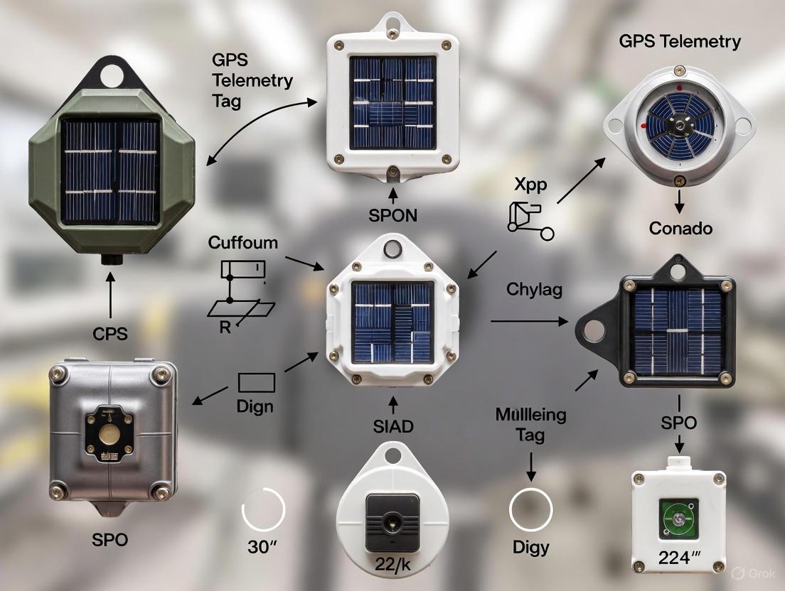
Selecting the appropriate tracking device is a critical decision that balances research objectives, species-specific constraints, and technological capabilities. The fundamental principle is that the device should not harm the animal or alter its natural behavior; for birds, a device should typically not exceed 3-5% of the animal's body weight [14]. This guide details the diverse tag types available, their applications, and standardized protocols for their use in scientific research.
Tag Type Comparison and Selection
The table below provides a quantitative comparison of the primary electronic tracking devices used in animal movement research.
Table 1: Comparative Analysis of Animal-Borne Tracking Devices
| Tag Type | Typical Weight Range | Key Technologies | Spatial Accuracy | Data Access Method | Primary Applications |
|---|---|---|---|---|---|
| GPS Ear Tag | >10g [13] | GPS, Cellular/Satellite | ~41m to ~59m [13] | Remote (GSM/Satellite) | Livestock management, wildlife tracking [22] |
| GPS Collar | >10g [13] | GPS, Argos, UHF | ~2m [13] | Remote (GSM/Satellite) or Direct | Large mammal tracking, ecology studies [23] |
| Platform Terminal Transmitter (PTT) | ~2g and above [14] | Doppler Shift, Argos | 150m - 5000m [14] | Remote (Satellite) | Long-distance migration of birds [14] |
| Radio Transmitter | <5g [14] | VHF Radio | Limited to receiver range | Direct (Manual Tracking) | Small-scale movement studies [14] |
| Geolocator | <5g [14] | Light-level Sensors | ~200km [14] | Direct (Device Recovery) | Approximate migratory pathways [14] |
| Marine Tag (e.g., SPOT/SPLASH) | Varies (deployed on marine mammals) [24] | Argos, Fastloc GPS | Varies (GPS is more accurate) [24] | Remote (Satellite) | Marine mammal movement & dive behavior [24] |
Selection Workflow Logic
The following diagram outlines the logical decision process for selecting the most appropriate animal tracking tag based on research priorities and species constraints.
Experimental Protocols for Deployment
Adhering to standardized protocols ensures the scientific rigor of tracking studies and prioritizes animal welfare.
Protocol: Deploying GPS Ear Tags on Livestock
Objective: To securely attach a GPS ear tag for monitoring location, herd movement, and health metrics in a ranch setting [22].
Table 2: Research Reagent Solutions for GPS Ear Tag Deployment
| Item Name | Function/Brief Explanation |
|---|---|
| Solar-Powered GPS Ear Tag | Tracking device; solar power extends battery longevity for long-term studies [13]. |
| Livestock Restraint Chute | Safely and humanely immobilizes the animal during the tagging procedure. |
| Disinfectant Wipes/Swabs | Cleans the ear pre-deployment to minimize infection risk (e.g., 70% isopropyl alcohol). |
| Applicator Tool | Specialized tool designed for the specific tag model to ensure correct and secure application. |
| Data Logging Software/Dashboard | Platform (e.g., proprietary cloud software) to receive, visualize, and analyze transmitted GPS data [25]. |
Methodology:
- Animal Restraint: Guide the animal into a restraint chute to minimize stress and ensure handler safety.
- Site Preparation: Identify the tagging site (typically the center of the ear). Remove dirt and debris, then thoroughly disinfect the area.
- Tag Application: Load the tag into the applicator tool. Position the applicator precisely on the marked site and deploy in a single, swift motion to ensure a clean penetration.
- Post-Application Check: Verify the tag is seated correctly and not overly tight. Apply a topical antiseptic to the wound site if necessary.
- Data Verification: Release the animal and confirm the tag is transmitting location data successfully to the online dashboard or software platform [25].
Protocol: Fitting a GPS Collar on a Large Terrestrial Mammal
Objective: To deploy a GPS collar on a large mammal (e.g., wolf, deer) to collect high-accuracy movement data and study home range, habitat use, and behavior [23].
Methodology:
- Animal Capture: A trained veterinarian or wildlife biologist must perform the capture using safe and approved methods (e.g., chemical immobilization via darting).
- Animal Welfare Monitoring: Continuously monitor the animal's vital signs (heart rate, respiration, body temperature) throughout the procedure.
- Collar Fitting: Place the collar around the animal's neck. Ensure you can fit two fingers between the collar and the neck to prevent injury or choking as the animal grows or seasons change.
- Data Logger Programming: Configure the GPS collar's settings (e.g., fix schedule, data transmission interval) according to the research plan before release.
- Release and Monitoring: Administer antagonists to reverse immobilization drugs in a safe, controlled manner. Monitor the animal until it fully recovers and ambulates normally.
Protocol: Deploying a PTT on a Migratory Shorebird
Objective: To track the long-distance migration of a small to medium-sized shorebird using a lightweight Platform Terminal Transmitter (PTT) [14].
Table 3: Research Reagent Solutions for Shorebird PTT Deployment
| Item Name | Function/Brief Explanation |
|---|---|
| Platform Terminal Transmitter (PTT) | Miniaturized satellite transmitter; weight must be <2-3g for small shorebirds [14]. |
| Leg-Loop Harness | Attachment system made of soft, degradable material (e.g., elastic) to minimize long-term impact [14]. |
| Field Scales | Precision scales (e.g., 0.1g accuracy) to weigh the bird and ensure the device is <5% of body mass. |
| Argos Satellite System | Satellite network used to receive transmissions from the PTT and calculate location estimates [14]. |
Methodology:
- Capture and Processing: Capture the bird using a mist net. Weigh and record morphological measurements.
- Harness Fitting: Carefully thread the bird's legs through the pre-fashioned leg loops of the harness. Adjust the harness to fit snugly but without restricting movement.
- Attachment: Secure the PTT to the harness on the bird's back. Verify the fit does not interfere with flight, feeding, or preening.
- Release: Release the bird at the capture site and observe initial flight behavior.
- Data Acquisition: Locations are calculated via the Argos satellite system based on Doppler shift, with accuracy varying from 150m to several kilometers [14].
Technological Foundations and Data Processing
Understanding the underlying technology is crucial for data interpretation and system design.
Core Tracking Technologies and Data Flow
The diagram below illustrates the core technologies and signaling pathways involved in modern wildlife tracking systems.
Protocol: Improving Spatial Accuracy in Radio Telemetry
Objective: To enhance the accuracy of location estimates in an Automated Radio Telemetry System (ARTS) using a grid search algorithm instead of traditional multilateration [18].
Methodology:
- System Setup: Establish a network of fixed radio receivers with overlapping detection ranges within the study area.
- Signal Strength Modeling: Fit an exponentially decaying function (S(d) = A - B exp(-C d)) to characterize the relationship between Received Signal Strength (RSS) and distance using calibration data from known locations [18].
- Data Collection: Record the RSS of a target animal's transmitter at multiple synchronized receivers.
- Grid Search Execution:
- Superimpose a fine-scale grid over the study area.
- For each grid cell, calculate the distance to every receiver that detected the signal.
- Compute a likelihood score (e.g., χ²) comparing the observed RSS values with the model-predicted values for that cell [18].
- Location Estimation: Identify the grid cell with the lowest χ² value, which represents the most probable location of the animal. This method has been shown to be more than twice as accurate as multilateration in experimental conditions [18].
Ethical and Regulatory Considerations
The proliferation of biologging devices necessitates rigorous ethical review. Evidence suggests a significant proportion of tracking projects fail to generate published scientific knowledge, potentially trivializing this invasive technology [19].
Researchers must justify projects with clear objectives, explore non-invasive alternatives, and use the minimum sample size required for robust results, adhering to the "Replace, Reduce, Refine" framework [19]. Regulations must ensure that the welfare of the studied individuals is paramount and that the data collected culminates in tangible conservation or scientific outcomes [19].
Advanced Applications and Deployment Strategies in Contemporary Research
The use of Global Positioning System (GPS) telemetry tags has revolutionized animal movement tracking research, enabling unprecedented insights into the ecology and behavior of diverse species. This capability carries a significant ethical responsibility to minimize harm and disturbance to the studied animals. Adherence to species-specific protocols is not merely a methodological preference but a fundamental component of ethical research and conservation practice. These protocols ensure that the data collected accurately reflect natural behaviors and that the welfare of individual animals and their populations is safeguarded.
The core ethical framework for biologging is guided by the Three Rs principle: Reduction, Refinement, and Replacement [26]. Researchers must justify that the number of animals tagged (Reduction) is the minimum necessary for robust scientific inference, refine tagging methods and device designs to minimize animal welfare impacts (Refinement), and consider alternative, less invasive methods where possible (Replacement). A growing body of evidence indicates that tracking devices can have measurable effects on animal behavior, reproduction, and survival [27]. Therefore, a one-size-fits-all approach is ethically and scientifically untenable; protocols must be tailored to the specific morphology, ecology, and physiology of the target species.
Pre-Deployment Planning and Justification
Experimental Justification and Objective Setting
Prior to any animal capture or device deployment, researchers must clearly define the scientific and conservation objectives. The research questions should be of sufficient importance to justify the potential disturbance and risk associated with tagging. GPS technology is particularly powerful for addressing questions related to fine-scale resource selection, migration ecology, and human-wildlife conflict [28]. The study design must also account for the high cost of GPS units, which often forces a trade-off between collar capabilities and sample size, potentially weakening population-level inference [28]. A power analysis should be conducted to determine the minimum sample size required to achieve the stated objectives, ensuring that the study is scientifically valid and that the use of animals is justified.
Animal Welfare Risk Assessment
A comprehensive risk assessment is a critical precursor to any tagging operation. This assessment should consider:
- Capture and Handling: The stress and risk associated with capture, restraint, and sedation.
- Device Impact: The potential for the device to cause increased energy expenditure, changes in behavior, injury, or elevated predation risk.
- Device Mass and Design: The device's mass, shape, aerodynamics, and hydrodynamics must be evaluated for the specific species. The traditional guideline that a device should be less than 2-5% of the animal's body weight is a common but debated starting point; one analysis of bird studies found that tagging produced small but significant impacts on survival and reproduction [27]. Physical modeling of how a tag might affect an animal's movement (e.g., flight, climbing, or running) is a recommended practice for predicting and mitigating impacts [27].
Table 1: Key Considerations in Pre-Deployment Ethical Review
| Consideration | Description | Ethical Principle |
|---|---|---|
| Scientific Merit | Are the research questions clearly defined and can they justify the potential impact on the animal? | Reduction |
| Species Suitability | Is the target species appropriate for tagging given its conservation status, life history, and morphology? | Replacement |
| Device Selection | Has the smallest, lightest, and most streamlined device been selected for the research objectives? | Refinement |
| Sample Size | Has a power analysis been conducted to use the minimum number of animals for robust inference? | Reduction |
| Permitting | Have all required approvals from institutional, governmental, and journal ethics boards been obtained? | N/A |
Species-Specific Protocol Development
Device Selection and Customization
Choosing the appropriate tag type is a critical species-specific decision. For marine animals, options range from transmitting tags that send data via satellites like Argos for wide-ranging species, to pop-up archival tags (PATs) that record data and then release to transmit [29]. For pinnipeds (seals and sea lions), a key distinction is made between externally attached telemetry devices (ETDs) and fully implanted devices, with ETDs being less invasive but having limited retention times [26].
The attachment method must be customized to the species. For pinnipeds, common attachments include glue, epoxy, or harnesses, each with different trade-offs regarding retention, hydrodynamic profile, and potential for injury [26]. Device deployment duration should be planned to answer the scientific question while minimizing the time the animal carries the device. For long-term studies, researchers should consider deploying tags with a automatic release mechanism to avoid the device becoming a permanent fixture or requiring recapture for removal.
Capture, Handling, and Attachment Procedures
Standardized operating procedures for capture and handling are essential for animal welfare and data quality. The following workflow diagram outlines the key stages from planning to post-release monitoring.
Animal Capture and Restraint
The capture method (chemical immobilization, physical restraint, or remote capture) must be selected by professionals trained for the specific species. The goal is to minimize the duration of the capture event and the stress on the animal. For many marine mammals, procedures should be conducted on land when possible to reduce the risk of drowning [26]. A thorough health assessment should be performed prior to device attachment; animals showing signs of excessive stress or poor health should be released without a tag.
Device Attachment and Data Collection
The attachment site must be prepared according to best practices, which may involve cleaning, drying, and, for glued attachments, potentially shaving the area to improve adhesion [26]. The device should be attached swiftly and securely by a trained individual. Alongside attachment, researchers should collect valuable morphometric and biological data (e.g., weight, length, blubber thickness, blood, whisker, or fur samples) to maximize the scientific return from a single handling event, provided these activities do not unduly prolong the procedure.
Post-Release Monitoring and Impact Assessment
Monitoring the tagged animal after release is a critical but often overlooked component of ethical tagging. Direct observation immediately post-release can provide early indicators of adverse effects. Long-term monitoring via the tag itself and, where possible, subsequent re-sightings, is necessary to assess the device's impact on behavior, body condition, and survival. The gold standard for impact assessment is the use of a control population of untagged animals [27]. Comparing life-history traits like survival rates, reproductive success, and foraging efficiency between tagged and untagged individuals provides the most robust data on device effects and is essential for refining future protocols.
Data Management and Reporting Standards
Data Compilation and Standardization
The value of telemetry data is magnified when combined across studies, enabling large-scale analyses of animal movement and distribution. However, combining datasets is challenging due to variations in study design, tracking methods, and data structures. A standardized compilation pipeline is recommended, which includes phases for dataset pre-processing, formatting to a common template, binding, error checking, and filtering [20]. Such a pipeline helps flag erroneous locations (a known issue with satellite telemetry) and standardizes attributes for analysis [20]. Database projects like Movebank and the Marine Mammals Exploring the Oceans Pole to Pole (MEOP) consortium are leading efforts to store and standardize biologging data, making them accessible to the broader research community [27].
Transparent Reporting and Data Sharing
Full and transparent reporting of methods is essential for the critique, replication, and refinement of tagging protocols. Publications should include detailed information on:
- Device specifications (mass, dimensions, attachment method).
- Capture and handling protocols (duration, drugs used).
- Any observed or potential impacts on the animal. This level of detail allows for future meta-analyses that can improve best practices [27]. Furthermore, following the FAIR principles (Findable, Accessible, Interoperable, and Reusable) for data sharing maximizes the collective scientific return from the individual animal's contribution and aligns with the Reduction principle of the Three Rs.
Table 2: Essential Research Reagents and Materials for GPS Telemetry Studies
| Item Category | Specific Examples | Function and Application |
|---|---|---|
| Tag Types | GPS/Argos collars (terrestrial), CTD-SRDL tags (marine), Pop-up Archival Transmitting (PAT) tags | Gather and transmit fine-scale spatio-temporal data on location, behavior, and/or environmental conditions [29] [28] [27]. |
| Attachment Materials | Adhesives (epoxy, glue), custom-fitted harnesses, satellite bands | Securely affix the telemetry device to the animal's body in a way that minimizes drag and injury risk [26]. |
| Capture & Health Assessment | Chemical immobilants, biologgers for physiology (e.g., "daily diary" tags), stethoscope, blood collection kits | Safely restrain animals for tagging and collect baseline health and physiological data to assess procedure impact [27] [26]. |
| Data Infrastructure | Movebank, MEOP database, custom compilation pipelines | Store, standardize, error-check, and share the large volumes of tracking data generated [27] [20]. |
The ethical deployment of GPS telemetry tags requires a committed, ongoing practice of justification, refinement, and transparency. There is no single correct protocol; instead, best practices emerge from a conscientious application of general principles—the Three Rs—to the specific context of the research question and the target species. As a field, biologging must continue to advance on several fronts to uphold its ethical commitments.
Future directions should focus on:
- Technology Development: Creating smaller, smarter, and less invasive tags, including those that can collect data on the device's impact on the animal itself [27].
- Validation Studies: Conducting more rigorous, controlled studies to move beyond simplistic rules of thumb (e.g., 2-5% body weight rule) and build a predictive understanding of how device design and attachment affect different species [27].
- Standardized Experimental Design: Implementing robust study designs, including control populations, as a standard requirement for biologging studies to properly quantify impacts [27].
- Universal Data Sharing: Embracing a culture of open data through centralized databases to maximize knowledge gain per animal tagged and facilitate large-scale ecological analyses [27] [20].
By adhering to detailed, species-specific protocols and actively pursuing these future goals, researchers can ensure that the powerful tool of GPS telemetry continues to provide critical insights for ecology and conservation while maintaining the highest standards of animal welfare.
The field of wildlife telemetry has evolved beyond simple location tracking into a sophisticated discipline capable of capturing rich, multi-dimensional datasets about animal lives. Multi-sensor integration represents the cutting edge of this transformation, enabling researchers to move from merely documenting where an animal is to understanding what it is experiencing physiologically and environmentally in near real-time [1] [30]. Modern telemetry tags now function as mobile field laboratories, carrying suites of miniaturized sensors that capture behavioral, physiological, and environmental metrics simultaneously with position data [30]. This technological evolution is revolutionizing ecological research, conservation planning, and our fundamental understanding of species biology in a rapidly changing world.
The core advancement lies in the ability to correlate location data with contextual information. While GPS provides precise movement trajectories, integrated sensors reveal the underlying drivers and consequences of that movement—from the physiological cost of navigating difficult terrain to the environmental conditions an animal selectively experiences [28] [30]. This multi-dimensional approach has revealed critical limitations in studies relying solely on location data, which often force researchers to infer behavior and physiology indirectly [28]. By directly measuring these parameters, integrated sensor systems provide mechanistic understanding of animal movement, energy expenditure, health status, and response to environmental change.
The Integrated Sensor Toolkit: Capabilities and Applications
Modern animal-borne sensors can be broadly categorized into three functional classes: those measuring behavior, physiology, and environment. When deployed in combination, these sensors transform standard tracking studies into holistic investigations of animal ecology.
Table 1: Sensor Categories and Their Ecological Applications
| Sensor Category | Specific Metrics Measured | Research Applications | Example Technologies |
|---|---|---|---|
| Behavioral Sensors | Acceleration, tilt angle, direction, swimming depth/flight altitude, feeding events, proximity to conspecifics [30] | Quantifying energy expenditure, identifying specific behaviors (e.g., foraging, resting), studying social interactions, documenting predation events [30] | Tri-axial accelerometers, magnetometers, depth sensors, proximity loggers [30] |
| Physiological Sensors | Body temperature, heart rate (ECG), muscular activity, gastric activity, sound production [30] | Monitoring stress responses, estimating metabolic rate, tracking reproductive status (e.g., pregnancy), detecting illness [30] | Thermistors, implantable physio-loggers (e.g., Star-Oddi), acoustic transmitters [31] [30] |
| Environmental Sensors | Ambient temperature, salinity, dissolved oxygen, irradiance, magnetic field intensity [30] | Documenting habitat selection, mapping microclimates, studying climate change impacts, understanding oceanographic correlations [30] | CTD loggers, photodiodes, dissolved oxygen sensors, magnetometers [30] |
Behavioral Sensing Beyond Movement
Accelerometers have emerged as particularly versatile behavioral sensors. These devices measure the dynamic acceleration of an animal's body, providing high-resolution data that can be used to distinguish between walking, running, flying, swimming, and resting states with high certainty [30]. When combined with GPS data, accelerometry can reveal how landscape features influence energetic costs of movement. Additional behavioral sensors like magnetometers (measuring direction) and depth sensors provide crucial context for interpreting movement paths in three-dimensional environments [30].
Physiological Status Monitoring
The ability to monitor an animal's internal state represents a quantum leap in ecological telemetry. Implantable physio-loggers, some weighing as little as one gram, can measure core body temperature, ECG-based heart rate, and activity in diverse taxa [31]. These data streams provide insights into energy use, stress responses, feeding ecology, and migration physiology that were previously inaccessible without invasive laboratory studies [31] [30]. For example, heart rate patterns can indicate exercise intensity during migration, while body temperature profiles may reveal fever responses to infection.
Environmental Context Recording
Environmental sensors mounted on animal-borne tags effectively transform studied animals into biospheric probes that sample conditions within their immediate habitat [30]. These sensors document the precise environmental parameters an animal experiences, eliminating guesswork about habitat characteristics. For marine species, tags can measure salinity, depth, and water temperature [30]. For terrestrial species, ambient temperature and irradiance sensors can reveal microclimate selection [30]. For species navigating using Earth's magnetic field, magnetometers can document field intensity during movements [30].
Figure 1: Architecture of an integrated multi-sensor telemetry tag showing the convergence of behavioral, physiological, and environmental data streams into a unified dataset for ecological analysis.
Data Processing, Transmission, and Analysis Frameworks
The rich data streams generated by multi-sensor tags present significant challenges in data processing, transmission, and analysis. Effective integration requires specialized hardware and software approaches to transform raw sensor readings into biologically meaningful information.
Data Transmission and Platform Considerations
The choice of data transmission technology represents a critical trade-off between device weight, data volume, battery life, and geographic coverage. Satellite-based systems (Argos, Iridium) enable global tracking but have limited bandwidth for transmitting high-volume sensor data [1]. GSM networks offer higher data throughput but are restricted to areas with cellular coverage [1]. Emerging satellite constellations specifically designed for IoT connectivity, such as the 25 nanosatellites being deployed by Kinéis, promise improved data transmission from remote areas using low-cost, low-energy devices [1]. For studies requiring high temporal resolution sensor data, on-board data logging with future recovery remains the only viable option for some applications, despite the obvious limitations [14].
Table 2: Data Transmission Technologies for Multi-Sensor Tags
| Transmission Technology | Data Capability | Coverage | Power Requirements | Best Suited Applications |
|---|---|---|---|---|
| Satellite (Argos/Iridium) | Low-moderate data volume | Global | High | Long-distance migrants, marine species, remote regions [1] |
| GSM Cellular Networks | Moderate-high data volume | Network coverage areas | Moderate | Peri-urban and suburban species, areas with reliable coverage [1] |
| LoRaWAN/Sigfox | Low data volume, long range | 5-200 km with local antennas | Low | Regional movements, fixed study areas [31] |
| Archival (Data Logging) | Very high data volume | Not applicable | Very low | All applications where recapture is feasible [14] |
| UHF Telemetry | Moderate data volume, high resolution | Local (up to several km) | Low | Fine-scale habitat use, behavior studies [31] |
Analytical Approaches for Integrated Data
The analysis of multi-sensor telemetry data requires specialized statistical approaches that can handle high-dimensional, correlated data streams with varying temporal structures [28]. Machine learning techniques, particularly supervised classification, have proven highly effective for identifying behavioral states from accelerometry data when combined with ground-truthed observations [30]. For spatial data, new algorithms like the grid search method for automated radio telemetry systems can significantly improve localization accuracy by comparing received signal strength across multiple receivers and finding the optimal fit to signal propagation models [18].
The integration of different data types often reveals emergent properties not apparent from any single data stream. For example, combining acceleration data (indicating active movement) with heart rate data (indicating metabolic cost) can reveal the energetic efficiency of different locomotion strategies. Similarly, correlating body temperature measurements with ambient environmental conditions can quantify thermal stress and behavioral thermoregulation [30]. These analytical approaches move beyond simple correlation to establish mechanistic links between animal physiology, behavior, and environment.
Essential Research Reagents and Equipment Solutions
Implementing a successful multi-sensor tracking study requires careful selection of hardware, software, and supporting technologies. The following table summarizes key solutions available from commercial suppliers and research institutions.
Table 3: Research Reagent Solutions for Multi-Sensor Telemetry Studies
| Product Category | Example Suppliers | Key Specifications | Research Applications |
|---|---|---|---|
| GPS/Satellite Tags with Sensors | e-obs, Vectronic Aerospace, Lotek, Telenax [31] | GPS with accelerometers, environmental sensors; remote data download; customizable sampling [31] | High-resolution movement studies; large mammal ecology; habitat selection [31] |
| Miniature Physio-Loggers | Star-Oddi [31] | Implantable design; measures temperature, heart rate, activity; devices as small as 1g [31] | Physiological monitoring in small vertebrates and aquatic species; metabolic studies [31] |
| Customizable IoT Sensors | Hardwario, Copernicus Technologies [1] [31] | Long battery life (years); multiple daily transmissions; customizable sensors [1] | Long-term environmental monitoring; anti-poaching applications; regional tracking [1] |
| Automated Radio Telemetry | Ecotone [31] | Very light tags (≥60mg); multiple receiver arrays; high temporal resolution [18] | Small species tracking; fine-scale movement ecology; insect and herpetological studies [18] |
| Data Visualization Platforms | Mapotic [1] | Interactive mapping; data randomization for protection; public engagement tools [1] | Citizen science projects; conservation advocacy; educational applications [1] |
Experimental Protocol: Implementing an Integrated Sensor Study
The following protocol provides a framework for implementing a comprehensive multi-sensor tracking study, from hypothesis development through data analysis. This workflow integrates both technological and biological considerations to ensure robust experimental design and meaningful results.
Figure 2: Experimental workflow for implementing an integrated multi-sensor tracking study, showing key stages from initial planning through final data analysis.
Study Planning and Design Phase
Objective: Establish a clear conceptual framework linking research questions to specific sensor measurements.
Procedure:
- Define Primary Research Questions: Formulate specific, testable hypotheses that require integrated sensor data. Example: "Do elevated heart rates during mountain lion movements through urban interfaces indicate physiological stress responses?"
- Identify Critical Parameters: Select the minimum set of sensors needed to address research questions while respecting animal welfare constraints [14]. Consider both direct measurements (e.g., heart rate) and proxy measurements (e.g., activity from accelerometers as an indirect measure of energy expenditure).
- Determine Resolution Requirements: Establish the necessary temporal and spatial resolution for each data stream. Balance resolution against battery life and data storage/transmission limitations [14] [18].
- Power Analysis: Conduct statistical power analysis to determine appropriate sample sizes, considering potential tag failure rates and the trade-off between number of tags and cost [28]. GPS studies often suffer from small sample sizes due to high per-unit costs, potentially limiting population-level inference [28].
Hardware Selection and Configuration
Objective: Select appropriate tagging technologies that balance measurement capabilities with animal welfare considerations.
Procedure:
- Tag Selection: Choose tags that do not exceed 3-5% of the animal's body mass, with the lower threshold preferred for migratory species [14]. For species under 200g, specialized lightweight tags (e.g., Doppler PTT tags around 2g) may be necessary [14].
- Sensor Integration: Select a sensor suite that addresses research questions while minimizing size and power requirements. Consider integrated tags from commercial suppliers (e.g., e-obs, Vectronic Aerospace) that combine GPS with accelerometers and environmental sensors [31].
- Data Transmission Method: Choose between archival logging (requiring recapture), satellite transmission (global but limited bandwidth), GSM networks (higher throughput where available), or LoRaWAN/Sigfox (long-range, low-power for regional studies) based on study species and geography [1] [31].
- Attachment Method Testing: Test attachment methods (leg-loop harnesses, collars, adhesives, implants) on captive animals or models to ensure secure attachment while minimizing welfare impacts. Use degradable materials where appropriate to ensure eventual release [14].
Field Deployment and Data Collection
Objective: Deploy sensors on study animals and establish continuous data collection systems.
Procedure:
- Regulatory Compliance: Obtain all necessary permits and IACUC/animal ethics approvals before beginning fieldwork [32] [33]. Consult with veterinarians during protocol development, particularly for invasive procedures [32].
- Animal Capture and Handling: Use species-appropriate capture methods that minimize stress and risk to animals. Monitor vital signs during handling and abort procedures if animals show signs of severe distress.
- Tag Attachment: Apply tags using predetermined attachment methods. Record individual animal measurements (weight, size, condition) and any relevant biological samples at time of tagging.
- Post-Release Monitoring: When possible, observe tagged animals immediately after release to ensure normal behavior and assess short-term responses to tagging.
- Data Collection Infrastructure: Maintain and monitor receiver networks (satellite, GSM, or fixed stations) to ensure continuous data capture. Implement automated data quality checks to identify system failures promptly [18].
Data Integration and Analysis
Objective: Transform multi-sensor data streams into integrated datasets for analytical testing of research hypotheses.
Procedure:
- Data Cleaning: Apply sensor-specific calibration curves and filters to raw data. Identify and remove biologically implausible values resulting from sensor artifacts.
- Time Synchronization: Align all data streams to a common time standard, accounting for potential clock drift in individual tags.
- Sensor Fusion: Implement analytical approaches that combine data streams to create novel derived metrics. Examples include:
- Energy Expenditure: Combine accelerometry and heart rate data to estimate metabolic cost [30].
- Behavior Classification: Use machine learning to classify behavior states from acceleration patterns validated with direct observation [30].
- Environmental Correlates: Spatially explicit analysis of physiological metrics in relation to environmental conditions [30].
- Statistical Modeling: Apply appropriate statistical models that account for autocorrelation in time-series data and individual variation. Use mixed-effects models to separate population-level patterns from individual idiosyncrasies [28].
Multi-sensor integration represents the future of wildlife telemetry, transforming simple tracking devices into comprehensive biological monitoring platforms. The technology continues to advance toward smaller sizes, longer battery life, greater sensor diversity, and more sophisticated on-board processing capabilities. Emerging technologies like fluorescent tagging systems (e.g., BrightMarkers) may eventually enable non-invasive tracking of smaller species [34], while continued miniaturization will make integrated sensors available for progressively smaller taxa.
The ultimate promise of multi-sensor integration lies in its ability to create holistic portraits of animal lives—revealing not just movement paths, but the physiological costs of navigation, the environmental challenges faced, and the behavioral strategies employed to overcome them. As these technologies become more accessible and analytical methods more sophisticated, integrated sensor approaches will dramatically advance our understanding of animal ecology in rapidly changing environments and provide crucial insights for conservation management in the Anthropocene.
The study of animal movement has been revolutionized by advances in telemetry technology, with GPS telemetry tags serving as a cornerstone of modern movement ecology research [35]. These technologies have enabled a shift from discrete, small-scale studies to large-scale, collaborative networks that can generate unprecedented volumes of data and novel ecological insights. The 2025 Monarch Tracking Project represents a paradigm shift in this field, demonstrating how technological innovation combined with structured scientific collaboration can overcome previous limitations in tracking small, migratory species across continental scales.
This application note examines the Project Monarch collaboration as a case study in large-scale ecological research, detailing the groundbreaking technological specifications, experimental protocols, and data management frameworks that enabled the successful tracking of individual monarch butterflies from Canada to their Mexican overwintering sites. The project deployed over 400 ultralight transmitters across more than 20 partner organizations throughout North America, establishing a new model for collaborative wildlife telemetry research [15] [36].
The 2025 Monarch Tracking Project addressed a longstanding challenge in movement ecology: tracking small-scale migratory organisms throughout their complete migration cycle. Prior to this initiative, conventional tracking technology was too heavy for monarch butterflies, which weigh less than a gram, forcing researchers to rely on indirect methods or mark-recapture studies that provided limited data on migration pathways and survival [37]. The project's success has shattered these limitations, providing scientists with high-resolution, near-real-time data on individual butterflies as they navigate their epic journey south [15].
Table: Key Quantitative Metrics of the 2025 Monarch Tracking Project
| Project Aspect | Metric | Significance |
|---|---|---|
| Scale | >20 organizations across 4 countries | Demonstrates extensive collaborative framework |
| Technology Deployment | >400 BlūMorpho transmitters deployed | Unprecedented tracking capacity for small insects |
| Transmitter Weight | 60 milligrams | ~80% reduction from previous 0.15g proof-of-concept |
| Tracking Resolution | Near-real-time with high spatial accuracy | Enabled fine-scale movement analysis |
| Detection Network | Millions of smartphones as passive receivers | Novel approach to continental-scale coverage |
The project's significance extends beyond monarch conservation, serving as a proof-of-concept for collaborative research frameworks that can be applied to other migratory species. By pooling resources and data across institutions, the collaboration created something "far greater than the sum of its parts," in the words of Dr. David La Puma, Director of Global Market Development at Cellular Tracking Technologies [36]. This model demonstrates how standardized protocols and data-sharing agreements can facilitate powerful analyses that would be impossible for individual research groups.
Technological Specifications
The core innovation enabling the 2025 Monarch Tracking Project was the development of the BlūMorpho transmitter by Cellular Tracking Technologies (CTT). This revolutionary telemetry tag represents a significant advancement in miniaturization technology for wildlife tracking.
BlūMorpho Transmitter Specifications
The BlūMorpho transmitter weighs approximately 60 milligrams, making it the world's lightest wildlife transmitter and sufficiently lightweight for monarch butterflies [36]. This achievement required overcoming substantial engineering challenges that had previously made monarch tracking impossible. The breakthrough came in 2021 when CTT engineer Eric Johnson identified a new chipset, and the company leveraged in-house advanced manufacturing techniques including custom solar panels the size of a grain of rice and surface mount technology that enabled assembly of precision circuitry [15].
Table: Technical Specifications of BlūMorpho Transmitters
| Parameter | Specification | Notes |
|---|---|---|
| Weight | 60 mg | Represents critical threshold for insect tracking |
| Power Source | Solar-powered | Enables extended operation during migration |
| Operating Frequency | 2.4 GHz (Bluetooth) | Compatible with consumer devices |
| Detection Range | Variable based on receiver density | Enhanced by crowd-sourced network |
| Data Transmission | Bluetooth with Blū+ code enhancement | Enables smartphone detection |
Detection Network Infrastructure
The project employed a multi-layered detection network consisting of both dedicated wildlife receivers and everyday smartphones. The infrastructure included:
- Traditional Wildlife Receivers: Motus Wildlife Tracking System stations and Terra mini base stations provided dedicated detection capability [15].
- Smartphone Integration: The Project Monarch App transformed smartphones into passive receivers, creating an extensive crowd-sourced detection network [36].
- Blū+ Programming Code: Enhanced transmitters included additional programming that enabled them to tap into crowd-sourced location networks, dramatically increasing detection points [15].
The pivotal moment in network development occurred in November 2024 when a butterfly named "Lionel," equipped with the Blū+ code, provided the first high-resolution track of monarch migration ever recorded, with hundreds of detections along its route to St. Augustine, Florida [36]. This demonstrated the potential of leveraging existing consumer technology to create continental-scale tracking networks.
Diagram 1: BlūMorpho Detection Network Architecture. The system integrates dedicated receivers and consumer smartphones to create continental-scale tracking capability.
Experimental Protocols
Transmitter Deployment Protocol
The deployment of BlūMorpho transmitters on monarch butterflies followed standardized protocols to ensure data quality and animal welfare:
- Butterfly Capture: Monarchs were captured using standard aerial nets during their fall migration period. Care was taken to minimize wing damage and stress during capture.
- Sex Determination: Each individual was sexed based on wing morphology (males have a distinct black spot on each hind wing).
- Transmitter Attachment: The 60-milligram BlūMorpho transmitter was carefully affixed to the butterfly's thorax using a specially formulated, non-toxic adhesive that ensured secure attachment without impairing flight capability.
- Release Procedure: Tagged butterflies were released at the location of capture following a brief recovery period, with precise geographic coordinates recorded via GPS.
- Data Recording: For each deployment, researchers recorded the complete tag code, deployment date, sex of the butterfly, geographic location, and other relevant metadata [15].
The project incorporated research from James Madison University that quantified effects of tags on movement and behavior, confirming that survival was unlikely to be impacted in properly tagged individuals [15]. This welfare consideration was essential for ensuring ethical research practices and valid scientific results.
Data Collection and Management Protocol
The project implemented a rigorous data management pipeline to handle the volume and complexity of movement data generated by the tracking network:
- Data Acquisition: Location data was collected through multiple streams including dedicated receivers and the smartphone network.
- Pre-processing: Raw data underwent cleaning procedures to remove location errors and outliers that could misrepresent movement paths [21].
- Standardization: Data from multiple partners was formatted to a common template with standardized fields, enabling integration across the collaboration [20].
- Error Checking: Automated error checks flagged biologically implausible locations (e.g., sudden long-distance movements inconsistent with monarch flight capabilities).
- Data Integration: Cleaned and standardized data was compiled into a central database accessible to project partners through the Blū+ Portal [36].
This pipeline addressed the significant challenge of combining datasets from discrete studies spanning large geographic areas, which typically involves addressing variation in study designs, tracking methodologies, location uncertainty, and data attributes [20]. The standardized approach enabled powerful cross-site analyses while maintaining data integrity.
The Scientist's Toolkit: Research Reagent Solutions
Table: Essential Research Materials and Technologies for Large-Scale Insect Tracking
| Tool/Technology | Function | Specifications | Project Application |
|---|---|---|---|
| BlūMorpho Transmitter | Movement data collection | 60 mg, solar-powered, 2.4 GHz Bluetooth | Primary tracking device attached to monarchs |
| Project Monarch App | Crowd-sourced detection | iOS/Android compatible, passive detection | Turns smartphones into network receivers |
| Motus Wildlife Tracking System | Dedicated receiver stations | Fixed stations with defined detection ranges | Traditional wildlife telemetry infrastructure |
| Terra Mini Base Stations | Dedicated receiver stations | Portable or fixed installation | Supplementary detection capability |
| Blū+ Portal | Data management and visualization | Web-based platform with access controls | Central repository for collaborative data sharing |
| ATLAS System | High-resolution movement tracking | Reverse-GPS technology with sub-meter accuracy | Not used in monarch project but relevant for less mobile species [38] |
Data Processing and Analytical Framework
The project employed sophisticated data processing methods to transform raw location data into biologically meaningful information about monarch movement ecology.
Data Pre-processing Pipeline
High-throughput movement data requires extensive pre-processing to ensure analytical validity. The project implemented a cleaning pipeline with these key phases [21]:
- Dataset Pre-processing: Initial quality assessment and formatting of raw data streams.
- Formatting to Common Template: Standardization of data fields and structures across multiple contributors.
- Dataset Binding: Integration of discrete datasets into a unified database.
- Error Checking: Identification and flagging of potentially erroneous locations.
- Filtering: Removal of locations that fail quality thresholds.
This workflow balanced the need to reject location errors while preserving valid animal movements, a crucial consideration given that location error can exceed the animal's step size in high-throughput tracking, leading to mis-estimation of behaviors [21]. The pipeline included functionality to identify coordinates from recurrently visited locations, which may be of special ecological significance.
Movement Analysis Metrics
The project employed standard movement ecology metrics to analyze monarch migration patterns [35]:
- Step Size: The displacement between two consecutive coordinate fixes
- Turning Angle: The change in heading from one step to the next
- Net Squared Displacement (NSD): The square of the straight-line distance between the start of the trajectory and the current location
- Persistence Velocity: The speed of movement in the direction of heading
- First Passage Time: The time taken to exit a circle of prescribed radius from a relocation point
These metrics enabled researchers to characterize movement paths and identify behavioral modes across the migration trajectory. The analytical approach considered both Lagrangian methods (focusing on discrete-step constructs) and Eulerian methods (focusing on emergent space-use constructs) to provide a comprehensive understanding of migration dynamics [35].
Diagram 2: Movement Data Processing Pipeline. Raw location data undergoes multiple transformation stages to enable ecological analysis.
Collaborative Framework and Governance
The Project Monarch collaboration established a governance model that enabled unprecedented cooperation across more than 20 organizations. Key elements of this framework included:
- Resource Sharing: The collaboration provided free or reduced-cost transmitters to partners and waived access fees for data platforms [36].
- Standardized Protocols: All partners agreed to implement standardized data collection and reporting procedures.
- Data Sharing Agreement: Partners shared data through the Blū+ Portal and the Project Monarch app with clear terms of use.
- Publication Policy: The collaboration established a collective publication policy crediting all contributors while enabling individual research questions.
- Permitting Coordination: The project navigated the complex permitting requirements for international wildlife research across four countries.
This "rising tide that lifts all boats" approach, as described by Dr. La Puma [36], created a collaborative environment where shared resources and data produced greater scientific insights than would be possible through isolated efforts. The model demonstrates how large-scale ecological research can overcome traditional barriers of funding limitations and institutional competition.
The 2025 Monarch Tracking Project represents a transformative development in wildlife telemetry and collaborative ecological research. By combining groundbreaking miniaturization technology with an innovative crowd-sourced detection network and structured collaborative framework, the project has overcome previous limitations in tracking small migratory insects across continental scales.
The methodologies and frameworks established by this project have implications beyond monarch conservation, providing a template for future large-scale movement ecology studies. The successful integration of consumer technology into scientific data collection suggests promising avenues for expanding monitoring networks without proportional increases in dedicated infrastructure.
As of November 2025, tagged monarchs were entering the Monarch Butterfly Biosphere Reserve in Mexico, with partners using the app and handheld receivers to locate them [36]. With proper permitting, partners hope to deploy transmitters on monarchs leaving Mexico in spring 2026, tracking their return journey north and completing the full annual migration cycle for the first time.
The project demonstrates how technological innovation, when coupled with thoughtful collaborative governance, can expand the boundaries of ecological knowledge and provide new insights into one of nature's most spectacular phenomena: long-distance animal migration.
The field of movement ecology has been transformed by the advent of sophisticated data visualization and analysis platforms, which are essential for interpreting the massive and complex datasets generated by GPS telemetry tags. These platforms enable researchers to move beyond simple location tracking to gain integrated insights into animal behavior, environmental interactions, and ecosystem dynamics. The growth of bio-logging and animal tracking has created datasets of unprecedented volume and complexity, complying with the "Four Vs Framework" (Volume, Variety, Veracity, Velocity) of big data, which often exceeds the capacity of conventional analytical methods [39]. Modern platforms address these challenges by providing specialized tools for data management, analysis, and visualization, making sophisticated analytical methods accessible to researchers without requiring advanced programming skills.
The integration of these tools creates a powerful ecosystem for wildlife research. Platforms like Movebank serve as foundational databases for storing and managing animal tracking data, currently hosting over 9.1 billion locations and 8.2 billion other sensor records from more than 9,367 studies across 1,603 taxa [40]. Analysis platforms such as ECODATA and MoveApps build upon this foundation by providing specialized visualization and analytical capabilities, while end-user solutions like Mapotic facilitate public engagement and science communication. This integrated approach enables researchers to extract meaningful ecological insights from complex tracking data and effectively communicate their findings to both scientific audiences and the general public.
Table 1: Comparative Analysis of Wildlife Data Visualization and Analysis Platforms
| Platform | Primary Function | Key Features | Data Source Compatibility | Access Method | Use Case Examples |
|---|---|---|---|---|---|
| ECODATA | Analysis & Visualization | Open-source animation tools, temporal dynamics visualization, environmental context integration | Remote sensing data, direct wildlife observations, geospatial data | Standalone software tool | Elk/wolf movement in relation to roads and vegetation [41] |
| Mapotic | Data Visualization & Public Engagement | Interactive web maps, data filtering, delay features for anti-poaching | Argos Systems, Wildlife Computers, Movebank | Web platform and mobile apps | OCEARCH shark tracker, Sea Turtle Conservancy [1] [42] |
| Movebank | Data Management & Storage | Centralized database, data sharing, archiving, management | Various tracking devices and sensors | Online database platform | Hosting billions of animal locations for global research community [40] |
| MoveApps | Data Analysis | Serverless, no-code workflow design, reproducible analysis | Movebank integration, various tracking data formats | Web-based analysis platform | Migration segmentation, daily tag deployment reports [39] |
Table 2: Quantitative Performance Metrics of Platform Implementations
| Platform/Implementation | User Engagement Impact | Data Processing Scale | Technical Requirements | Notable Deployments |
|---|---|---|---|---|
| Mapotic (OCEARCH) | 25% increase in user engagement | N/A | API integration, customizable map layers | Shark tracking with improved donation outcomes [1] |
| Mapotic (Fahlo) | 350,000 users in 8 months | N/A | Mobile app framework, QR code integration | Wildlife tracking bracelets with e-commerce integration [1] |
| Mapotic (Sea Turtle) | Hundreds of thousands of monthly map views | Budget reduction for Google Maps by "tens of percent" | Weather and current visualization | Sea Turtle Conservancy migration tracking [1] |
| Movebank | Global research community | 9.1 billion locations, 9,367 studies | Cloud-based database system | Worldwide animal tracking studies [40] |
| MoveApps | 316 registered users (beta) | 49 available Apps | Serverless cloud computing | Migration mapping, data quality checks [39] |
Experimental Protocols for Platform Implementation
Protocol: ECODATA Implementation for Movement Analysis
Purpose: To analyze animal movements in relation to environmental factors and anthropogenic features using ECODATA's animation capabilities.
Materials and Equipment:
- Animal tracking data (GPS/Argos locations with timestamps)
- Environmental datasets (vegetation indices, weather data, topographic maps)
- Anthropogenic feature data (roads, wildlife crossings, urban areas)
- ECODATA software suite (open-source tool)
- GIS software for data preprocessing
Methodology:
Data Preparation and Integration:
- Compile animal tracking data in standardized format (CSV or Movebank format)
- Process remote sensing data to match temporal and spatial resolution of animal tracks
- Import anthropogenic feature layers (e.g., road networks, crossing structures)
- Ensure all datasets share common coordinate reference system
ECODATA Workflow Configuration:
- Initialize ECODATA project with temporal parameters matching study period
- Import and layer animal movement data
- Integrate environmental covariates as dynamic map layers
- Configure animation parameters (frame rate, temporal resolution)
Animation Generation and Analysis:
- Generate sequential frames showing animal movements against environmental context
- Identify patterns in movement behavior relative to environmental changes
- Analyze intersection with anthropogenic features (e.g., road crossings)
- Export animations for further analysis and visualization
Validation Approach: Compare identified patterns with traditional statistical analyses of movement data. Verify temporal correlations between environmental events and behavioral responses.
Application Example: In a case study of elk and wolves near Banff National Park, researchers used ECODATA to visualize migrations from northeast during late spring to summer ranges, revealing time spent near highways during peak traffic volumes [41].
Protocol: Mapotic Implementation for Conservation Engagement
Purpose: To create engaging public-facing wildlife tracking visualizations that support conservation efforts and fundraising.
Materials and Equipment:
- Wildlife tracking data (GPS/Argos/Iridium)
- Mapotic platform access
- Animal metadata (images, descriptions, biological information)
- Base map layers (satellite imagery, topographic maps)
Methodology:
Platform Configuration:
- Set up Mapotic instance with custom branding and design
- Configure data synchronization with tracking data sources (Argos, Movebank, or Wildlife Computers)
- Implement data delay protocols (2-48 hours) for anti-poaching security
- Customize map layers and visualization options
Data Integration and Enhancement:
- Establish automated data feed from tracking systems
- Enrich location data with multimedia content and animal profiles
- Implement filtering options based on species, individuals, or time periods
- Configure user engagement features (donation buttons, sharing options)
Deployment and Monitoring:
- Launch public-facing tracking website or mobile application
- Monitor user engagement metrics and map interactions
- Implement A/B testing for interface optimization
- Regularly update animal profiles and conservation content
Validation Approach: Track user engagement metrics (session duration, return visits), donation conversion rates, and audience growth.
Application Example: The OCEARCH shark tracker implementation resulted in 25% increased user engagement and stronger donor relationships, while the Sea Turtle Conservancy project achieved hundreds of thousands of monthly map views with reduced operational costs [1].
The Scientist's Toolkit: Essential Research Reagent Solutions
Table 3: Research Reagent Solutions for Wildlife Tracking Data Analysis
| Tool/Category | Specific Examples | Function/Purpose | Implementation Considerations |
|---|---|---|---|
| Satellite Telemetry Systems | Argos Systems, Iridium, Kineis | Global data transmission from remote locations, near real-time tracking | Kineis offers new generation of 25 nanosatellites for low-cost, low-energy solutions [1] |
| Advanced Tracking Hardware | Wildlife Computers tags, Hardwario IoT devices | Multi-sensor data collection (temperature, salinity, pulse, acceleration) | Devices can measure both animal physiology and environmental conditions [1] |
| Data Management Platforms | Movebank database | Centralized data storage, management, and sharing across research teams | Hosts 9.1 billion locations; enables data standardization and collaboration [40] |
| Analysis Workflow Tools | MoveApps platform | No-code, serverless analysis workflow design with reproducible results | 49 Apps currently available; uses Docker containers for long-term reproducibility [39] |
| Visualization Engines | Mapotic, ECODATA animation tools | Creation of engaging visualizations for both research and public audiences | Mapotic enables data randomization for anti-poaching security [1] [41] |
| Sensor Integration Systems | BLE beacons, temperature sensors, accelerometers | Enhanced data collection beyond simple location tracking | Enable monitoring of animal physiology and micro-environment [43] |
Technical Implementation and Workflow Design
The effective implementation of wildlife tracking data platforms requires careful consideration of technical architecture and workflow design. Modern platforms increasingly adopt serverless cloud computing systems to ensure long-term reproducibility and accessibility. MoveApps, for instance, implements a container-based architecture where each analysis module (App) runs in an isolated Docker container with defined programming languages, versions, and supporting software packages [39]. This approach minimizes cascading errors in interconnected workflows and ensures that analyses remain reproducible even as underlying computing environments evolve.
A critical technical consideration in platform implementation is data security and ethical management, particularly for endangered species. Mapotic addresses this through deliberate data randomization and delay features that prevent real-time tracking of sensitive animals, thus reducing poaching risks [1]. This ethical framework requires careful calibration of delay intervals (typically 2-48 hours) based on species movement patterns and conservation status.
The integration between platforms creates a powerful ecosystem for wildlife research. A typical implementation might involve:
- Data collection via GPS/Argos tags from manufacturers like Wildlife Computers
- Data management and storage in Movebank's standardized database
- Specialized analysis through MoveApps' reproducible workflows
- Advanced visualization using ECODATA's animation capabilities
- Public engagement through Mapotic's interactive mapping interfaces
This integrated approach enables researchers to leverage the unique strengths of each platform while maintaining data integrity throughout the research lifecycle. The platform interoperability is facilitated through standardized API connections and common data formats that enable seamless data exchange between systems [42] [39].
The evolving landscape of wildlife tracking data visualization and analysis platforms represents a transformative development in movement ecology. Platforms like ECODATA and Mapotic, integrated with data management systems like Movebank and analytical environments like MoveApps, provide researchers with an unprecedented capacity to extract meaningful insights from complex animal movement data. These tools enable both scientific discovery and effective conservation communication, bridging the gap between raw tracking data and actionable ecological understanding.
Future developments in this field will likely focus on enhanced real-time analytics for conservation applications, improved machine learning integration for pattern detection, and greater interoperability between specialized platforms. The continued growth of satellite constellations, such as Kineis' planned 25 nanosatellites for global IoT connectivity, will further expand data acquisition capabilities [1]. As these technologies mature, they will increasingly support critical conservation decisions, wildlife management strategies, and public engagement efforts essential for addressing biodiversity challenges in an rapidly changing world.
Application Notes: Diverse Implementations of Animal Telemetry
Animal-borne telemetry has revolutionized the study of wildlife ecology and behavior, providing unprecedented insights into animal movement, physiology, and their interactions with the environment. The following applications highlight the technology's versatility across fields, from conservation biology to the foundational sciences that inform human health.
Conservation and Wildlife Management
The primary application of GPS telemetry tags is in conservation science, where they provide critical data for protecting species and managing ecosystems.
- Monitoring Endangered Species: Telemetry enables real-time tracking of endangered animals, allowing conservationists to respond swiftly to poaching threats or habitat destruction [23]. For instance, tracking has been essential for studying rhinos, elephants, and large cats, with custom collars and even horn implants used for specific species [9] [44].
- Understanding Migration and Movement Ecology: GPS technology has been pivotal in mapping the migratory routes of wide-ranging species. This is crucial for identifying and protecting critical corridors and stopover sites [28]. Studies on animals from migratory songbirds to ocean-going tuna have revealed detailed movement patterns that were previously impossible to document [28].
- Mitigating Human-Wildlife Conflict: By understanding how large mammals move in relation to human settlements, researchers and managers can develop strategies to reduce conflicts. GPS data can predict potential conflict zones, enabling proactive measures [28].
- Assessing Climate Change Impacts: Long-term movement datasets allow scientists to analyze how changes in climate affect animal behavior and distribution. For example, tracking has documented shifts in polar bear and seal movements in response to changing sea ice conditions [28] [45].
Clinical and Preclinical Research Foundations
While direct application to human clinical trials is limited, the methodologies and data from animal telemetry provide a foundational bridge to preclinical research and understanding fundamental biological processes.
- Studies of Physiology and Energetics: Bio-logging devices often carry sensors beyond GPS, including accelerometers, thermometers, and heart rate monitors. Deployments on deep-diving cetaceans like Ziphius cavirostris record detailed depth, temperature, and conductivity data, providing insights into extreme physiology and energetics [46]. These principles are directly transferable to studying animal models in controlled research settings.
- Behavioral Response Studies: Controlled exposure experiments using telemetry tags quantify how animals respond to anthropogenic stressors, such as naval sonar [46]. The experimental framework—baseline, exposure, and post-exposure monitoring—mirrors protocols used in preclinical toxicology and efficacy studies, where animal behavior and physiology are monitored in response to a test compound.
- Contributions to Disease Ecology: Tracking has been identified as a tool for understanding the spread of communicable diseases, such as the H5N1 avian influenza strain, by monitoring the movements of potential host species [9]. This research is vital for modeling disease transmission dynamics at the wildlife-human interface.
Table 1: Quantitative Overview of Telemetry Applications in Key Studies
| Application Area | Species Example | Key Measured Parameters | Data Resolution & Longevity Trade-offs |
|---|---|---|---|
| Deep-dive Foraging Ecology | Ziphius cavirostris (Cuvier's beaked whale) | Depth, Time, Conductivity, Location | High-resolution time-series (5-min) for ~14 days vs. dive summaries for longer periods [46] |
| Migratory Pathway Mapping | Shorebirds (<200 g) | Location, Timestamp | Doppler PTT: ~2g, lower resolution. GPS: heavier, higher resolution [14] |
| Endangered Species Protection | African Elephants, Rhinos | Location, Activity, Mortality Signal | Long battery life (multiple years); location updates scheduled or on interrupt [9] |
| Human-Wildlife Conflict | Wolves, Large Carnivores | Location, Proximity to human settlements | Frequent location fixes to map fine-scale movement near interface zones [28] |
Experimental Protocols
The successful implementation of a telemetry study requires meticulous planning, from device selection and attachment to data collection and analysis. The following protocols outline best practices for different research scenarios.
Protocol 1: Tracking Wide-Ranging Marine Mammals for Behavioral Response
Application: This protocol is designed for studying the behavioral responses of deep-diving cetaceans to acute noise exposure, balancing data resolution with transmission longevity [46].
Workflow Diagram:
Methodology:
Tag Selection and Programming:
- Device: Satellite-linked bio-logger (e.g., SPLASH10 tag, Wildlife Computers) equipped with pressure, temperature, and conductivity sensors [46].
- Research Question Alignment: Choose data streams and sampling regimes based on the core trade-offs between data longevity, resolution, and continuity [46].
- For detailed within-dive response: Prioritize resolution and continuity. Program the tag to collect and transmit depth time-series data at a high temporal resolution (e.g., 5-minute samples). This provides a continuous record but consumes more battery, limiting longevity to approximately 14 days [46].
- For long-term behavioral context: Prioritize longevity. Program the tag to transmit dive behavior summaries (e.g., maximum depth, duration of dives exceeding a conductivity threshold). This conserves battery, enabling a longer deployment [46].
Animal Capture and Tag Deployment:
- Ethical Approval: Secure all necessary permits from relevant wildlife and ethics authorities before commencement [19].
- Tag Attachment: Deploy the tag via a remote, ballistically attached dorsal fin anchor. The attachment is designed to be non-recoverable and is expected to naturally detach during the animal's next molt [46].
Data Transmission and Collection:
- Primary Method (Satellite): The tag transmits stored data via the Argos satellite system during brief surfacing events. Due to the limited bandwidth of Argos and the animal's surfacing behavior, the daily data reception can be low (e.g., 20-30 uplinks/day) [46].
- Supplementary Method (Vessel-Based): To increase data yield, employ a boat-based UHF antenna and receiver system (e.g., Argos Goniometer) to directly intercept tag transmissions when in range, bypassing satellite constraints [46].
Data Processing and Analysis:
- Data Decoding: Use manufacturer-specific software to decode raw satellite messages into usable data formats (e.g., CSV).
- Path and Behavior Analysis: Analyze location data to create movement paths. Analyze depth time-series or dive summaries to classify behaviors (e.g., foraging dives, transit) and identify potential responses to exposure events.
Protocol 2: Tracking Small Migratory Shorebirds
Application: This protocol is optimized for studying the migration of small-bodied birds (<200 g), where device weight and size are critical constraints [14].
Workflow Diagram:
Methodology:
Device Selection:
- The choice is driven by the research question and the 3-5% body weight rule for device mass [14] [19].
- For Long-Distance Migration (Path A): Use a Platform Transmitter Terminal (PTT). These Doppler shift tags are lighter (e.g., ~2 g) and suitable for tracking global movements, but provide lower-resolution location data and are more expensive [14].
- For Small-Scale Movement (Path B):
- Use a GPS tag for high-resolution data. They are heavier but more cost-effective, ideal for studying habitat use at a finer scale [14].
- Use a Motus tag, which is a very small, lightweight VHF transmitter. It is detected by a coordinated network of fixed receiver stations. This system is low-cost and allows for large sample sizes, but data are only logged when an animal passes within range of a receiver [47].
Animal Capture and Tag Attachment:
- Capture: Use species-appropriate, humane capture methods such as mist nets or cannon nets.
- Harnessing: Use a leg-loop harness made with soft, degradable materials (e.g., elastic). This attachment method is chosen to minimize impacts on flight, behavior, and welfare, and is designed to fall off over time [14].
Data Retrieval and Analysis:
- PTT/GPS: Data are retrieved remotely via satellite systems (e.g., Argos).
- Motus: Data are automatically logged by receiving stations and aggregated in a central database (e.g., motus.org) [47].
- Analysis: Use GIS software and movement analysis tools (e.g., R packages) to map migratory flyways, identify stopover sites, and quantify migration timing.
The Scientist's Toolkit: Essential Research Reagents and Materials
The following table details key materials and technologies essential for conducting animal telemetry research.
Table 2: Key Research Reagents and Materials for Wildlife Telemetry
| Item Name | Function/Application | Technical Specifications |
|---|---|---|
| SPLASH10 Satellite Tag | A modular tag for recording and transmitting dive behavior, location, and environmental data from marine animals. | Sensors: Pressure, Temperature, Conductivity. Data Retrieval: Argos satellite uplink. Common deployment: Non-recoverable, ballistic attachment [46]. |
| Platform Transmitter Terminal (PTT) | A lightweight satellite transmitter for tracking long-distance migrations of smaller species. | Weight: Can be as light as 2-5 g. Technology: Doppler-based positioning (e.g., Argos). Use Case: Ideal for birds and small mammals where weight is a primary constraint [14]. |
| Motus Nano-Tag | A very small, lightweight radio transmitter for tracking small animals via a coordinated receiver network. | Weight: Can be < 0.2 g. Technology: Automated VHF radio telemetry. Advantage: Enables large-scale collaborative tracking with high sample sizes at lower cost [47]. |
| Argos Goniometer | A vessel-based or stationary UHF receiver system that intercepts data transmissions from tags to supplement satellite uplinks. | Function: Increases data yield by directly receiving transmissions, bypassing satellite pass limitations. Application: Critical in remote areas or for species with limited surface time [46]. |
| Leg-Loop Harness | A common, welfare-focused attachment method for birds. | Material: Soft, elastic cord designed to degrade over time. Design: Secures the tag to the body while minimizing feather wear and skin irritation [14]. |
Optimizing Data Integrity: Addressing Analytical Challenges and Technical Limitations
The advent of GPS telemetry has revolutionized movement ecology, enabling researchers to collect fine-scale spatio-temporal data on animal movement. However, the inferential power of these data is profoundly influenced by the temporal sampling regime employed. The selection of sampling intervals is not merely a technical detail but a fundamental methodological decision that directly shapes which behavioral processes can be detected and accurately characterized. This protocol examines the critical relationship between sampling frequency and behavioral inference, providing a framework for designing temporally optimized tracking studies.
Core Concepts and Trade-offs
The Sampling Trade-off Space
The design of GPS-based studies involves navigating several interconnected trade-offs, primarily driven by battery limitations and tag weight constraints [48]. Researchers must balance:
- Sampling Frequency vs. Study Duration: Higher sampling frequencies (e.g., one location per second) deplete battery faster, reducing the overall duration of data collection. Conversely, sparse sampling extends duration but may miss critical, short-duration behaviors [48].
- Sample Size vs. Tag Cost: The high cost of GPS units often forces a trade-off between deploying more units for robust population-level inference and equipping units with more capable (and expensive) batteries for intensive sampling [28].
- Synchronization vs. Habitat: Denser habitats, such as forests, can cause tags to take variable amounts of time to acquire satellites. This reduces the synchrony of location fixes across tags, complicating the analysis of social interactions [48].
Impact of Sampling Interval on Behavioral Inference
The temporal grain of data collection dictates the ecological phenomena that can be observed.
- Fine-Scale Sampling (seconds to minutes): Essential for capturing dynamic social interactions (e.g., collective decision-making), area-restricted search (ARS) behavior, and precise foraging events. Short, consecutive bursts of fixes are needed to quantify movement parameters like speed and turn angle [48] [49].
- Coarse-Scale Sampling (hours to days): Suitable for investigating broad-scale habitat selection, home range estimation, and seasonal migration patterns. While these patterns can be inferred from less frequent data, coarse sampling introduces significant challenges in accounting for temporal autocorrelation [50].
Table 1: Behavioral Context and Recommended Sampling Design Considerations
| Behavioral Context | Target Behaviors | Recommended Sampling Strategy | Key Considerations |
|---|---|---|---|
| Social Behavior | Collective movement, proximity, contact | High-frequency bursts (e.g., 1 Hz); high group coverage | Synchronization errors are critical; distance over-estimation is greatest when individuals are close [48]. |
| Foraging Ecology | Area-restricted search, prey capture | High-frequency sampling; validation with ancillary sensors (e.g., acoustics) [49] | First-passage time and Hidden Markov Models are effective for identifying foraging segments [49]. |
| Habitat Selection | Resource use, space use | Regular or LARI sampling over long duration [51] | Marginalized space-time point processes (mSTPPs) can integrate over time to improve inference of space use [50]. |
| Migration & Dispersal | Onset, path, termination | Less frequent, long-term sampling | Balances battery life with the need to capture large-scale movements over extended periods. |
Experimental Protocols for Sampling Interval Optimization
Protocol: Evaluating GPS Performance for Social Behavior Studies
This protocol, adapted from He et al., assesses how sampling design and habitat affect the accuracy of inter-individual distance estimates, which is crucial for studying social behavior [48].
- Tag Deployment: Deploy multiple GPS tags in static configurations and during movement transects. Place tags in pairs or small arrays at known, measured distances from each other, covering a range of distances relevant to the species' social spacing (e.g., 0.5m to 10m).
- Habitat Variation: Repeat deployments in different habitat types (e.g., open grassland, closed canopy forest) to quantify the effect of vegetation cover on GPS error and synchrony.
- Sampling Regime Variation: Program tags with different inter-fix intervals (e.g., 1 second, 5 minutes, 1 hour) and burst durations to collect data for performance comparison.
- Data Analysis:
- Calculate the error in estimated positions for static tags.
- Quantify the over-estimation bias in inter-tag distances, noting that this bias is greatest for tags in close proximity [48].
- Assess the correlation of errors between nearby tags, which can partially mitigate distance estimation errors.
- Measure the synchrony of location fixes across tags programmed to record at the same time.
Protocol: Validating Behavior Inference with Ancillary Data
This protocol uses independent behavioral validation, as demonstrated with echolocating bats, to evaluate the performance of path segmentation methods [49].
- Multi-sensor Data Collection: Deploy GPS tags integrated with other sensors that provide direct evidence of behavior. In the case of bats, this was an ultrasonic microphone to record "feeding buzzes" indicating prey capture attempts [49].
- Path Segmentation: Apply multiple segmentation algorithms (e.g., Hidden Markov Models, First-Passage Time, k-means clustering) to the GPS track to infer behavioral states (e.g., foraging vs. commuting) [49].
- Validation: Compare the inferred behavioral states from each segmentation method against the ground-truth data from the ancillary sensor (e.g., the presence of a feeding buzz).
- Performance Evaluation: Calculate evaluation metrics such as true positive rate (buzzes occurring during predicted foraging) and balanced accuracy to determine which segmentation method and underlying sampling regime most accurately identifies the behavior of interest [49].
Advanced Sampling Frameworks and Analytical Tools
Lattice and Random Intermediate Point (LARI) Sampling
A novel sampling regime proposed by Penn State statisticians combines regular and irregular time points to maximize information capture [51].
- Concept: Data are collected at regular intervals (the lattice) and at one random time point between each regular interval.
- Advantage: This method captures both regular, periodic behaviors and more sporadic, event-driven behaviors more effectively than strictly regular sampling with the same number of data points. It has been shown to yield more accurate and precise estimates of movement parameters [51].
- Implementation: For a GPS tag programmed to record a location every 2 hours, the controller would be set to randomly trigger an additional fix once within each 2-hour interval.
The workflow below illustrates the application of the LARI sampling framework.
Analytical Approaches for Different Temporal Scales
The analytical method must be matched to the sampling regime and research question.
- For Fine-Scale Data (Behavioral Segmentation): Methods like Hidden Markov Models (HMMs) and First-Passage Time (FPT) are used to parse high-frequency tracks into discrete behavioral states (e.g., resting, foraging, commuting). Validation studies have shown HMMs to be particularly effective [49].
- For Large-Scale Patterns (Space Use): Marginalized Space-Time Point Processes (mSTPPs) integrate over the time dimension to focus on broader spatial patterns of habitat selection and space use. This approach reduces model complexity and improves prediction accuracy for home range and species distribution models [50].
The following diagram summarizes the decision process for linking research questions with appropriate sampling and analytical methods.
Table 2: Key Research Reagent Solutions and Platforms for Movement Ecology
| Tool / Platform | Type | Primary Function | Relevance to Sampling Design |
|---|---|---|---|
| Movebank [40] | Data Repository | Online database for managing, sharing, and archiving animal tracking data. | Provides a platform for storing and accessing high-volume tracking data from various sampling regimes. Hosts billions of locations. |
| MoveApps [39] | Analysis Platform | A no-code, serverless platform for analyzing animal tracking data via reusable workflows (Apps). | Enables accessible application of analysis methods (e.g., segmentation) to data from different sampling designs without coding. |
| ECODATA [41] | Visualization Tool | Suite of open-source tools for creating animations of animal movement in relation to dynamic environmental data. | Helps visualize and communicate the results of different temporal sampling strategies, revealing patterns in an intuitive format. |
| GPS Tags (e.g., Lotek NanoPin) | Hardware | Lightweight radio transmitters for tracking small animals (<100g). | Enables tracking of species unsuitable for larger GPS tags, with trade-offs in pulse interval and battery life [52]. |
| Bio-loggers (GPS-Acoustic) | Hardware | Integrated sensors (e.g., GPS + ultrasonic microphone). | Provides independent validation of inferred behaviors (e.g., foraging validated by feeding buzzes), critical for testing sampling efficacy [49]. |
In animal movement ecology, inferring unobserved behavioral states from tracking data is a fundamental challenge. Statistical models that translate raw location data into ecologically meaningful behaviors are crucial for understanding how animals interact with their environment. Among the many available methods, Movement Persistence Models (MPM), Hidden Markov Models (HMM), and the Mixed-Membership Method for Movement (M4) represent prominent but distinct approaches. This protocol provides a comparative analysis of these three methodologies, evaluating their performance, data requirements, and appropriate applications to guide researchers in selecting the optimal tool for their specific research questions within the context of GPS telemetry studies [53].
Model Comparison and Performance
The selection of a behavioral state model is not one-size-fits-all; it depends heavily on the temporal scale of the data and the specific behavioral states of interest. A recent empirical comparison on green sea turtle (Chelonia mydas) tracking data highlights how these factors influence model output [53].
Table 1: Comparative Performance of Behavioral State Models at Different Temporal Scales
| Model | Key Principle | 1-hour Time Step | 4-hour Time Step | 8-hour Time Step |
|---|---|---|---|---|
| MPM | Estimates a continuous behavioral parameter (autocorrelation in direction/speed) [53] | Identifies fine-scale patterns (e.g., resting during migration) [53] | Increasingly smoothed behavioral transitions [53] | Distinguishes ARS from migration [53] |
| HMM | Latent states switch via a Markov process; assumes parametric distributions [53] | Less effective at fine scales [53] | Estimates 3-5 states; similar to M4 [53] | Distinguishes ARS from migration with greater nuance [53] |
| M4 | Segments tracks into homogenous periods, clusters segments into states; non-parametric [53] | Less effective at fine scales [53] | Estimates 3-5 states; similar to HMM [53] | Distinguishes ARS from migration with greater nuance [53] |
Table 2: Summary of Model Characteristics and Data Requirements
| Characteristic | MPM | HMM | M4 |
|---|---|---|---|
| State Representation | Continuous (move persistence) [53] | Discrete [53] | Discrete (with mixed membership) [53] |
| Core Assumptions | Correlated random walk, Markov process [53] | Parametric distributions for metrics, Markov process [53] | Non-parametric; no mechanistic movement model [53] |
| Handling Missing Data | Requires pre-processing | Requires pre-processing | Accommodates missing values [53] |
| Key Strength | Superior fine-scale resolution [53] | Mature framework; can incorporate predictors [54] | Flexible; fewer distributional assumptions [53] |
| Key Consideration | May overlook complex discrete states | Critical selection of movement metrics [53] | Care needed with missing data and metric selection [53] |
Experimental Protocols for Model Application
The following protocols outline the standard workflow for applying each model to animal tracking data, from preparation to inference.
General Data Pre-Processing Workflow
This initial stage is critical for all subsequent modeling.
- Data Filtering: Remove erroneous locations. For Argos data, exclude positions with missing quality classes (e.g., class Z) or implausible locations (e.g., on land for marine species) [53].
- Regularization: For HMMs and MPMs that often require regular time steps, interpolate locations to a consistent time interval (e.g., 1, 4, 8 hours). The choice of interval will significantly impact results [53].
- Movement Metric Calculation: Derive predictors from the location data. Common metrics include:
- Step Length: The straight-line distance between consecutive locations.
- Turning Angle: The change in direction between consecutive steps.
- Data Inspection: Visually explore the calculated metrics for outliers or patterns that may inform model setup.
The following diagram illustrates the general workflow for processing animal tracking data, which serves as the foundation for all three behavioral models.
Protocol for Hidden Markov Model (HMM)
HMMs assume an animal is in one of a finite number of discrete, latent behavioral states at each time step, with state switches governed by a Markov process [53].
Model Formulation:
- Define States: Propose a set of behavioral states (e.g., 2-5) such as "Transit," "Area-Restricted Search (ARS)," and "Resting" based on a priori knowledge.
- Specify Distributions: Select parametric probability distributions for the observed movement metrics (e.g., gamma distribution for step lengths, von Mises distribution for turning angles).
- State-Dependent Parameters: Allow the parameters of these distributions (e.g., mean, variance) to depend on the latent state.
Model Fitting:
- Fit the model to the prepared data (step lengths, turning angles) using maximum likelihood or Bayesian inference. This estimates the transition probability matrix and the state-dependent distribution parameters.
- The forward-backward algorithm can then be used to compute the probability of each state at each time point.
Validation and Interpretation:
Protocol for Mixed-Membership Method for Movement (M4)
M4 offers a flexible, non-parametric alternative that does not assume an underlying correlated random walk [53].
Track Segmentation:
- The algorithm first partitions the movement trajectory into segments separated by "breakpoints" where movement characteristics change significantly [53].
- Each segment is intended to represent a period of relatively homogeneous movement.
Segment Clustering:
State Assignment:
- The model assigns a behavioral state (or a mixture of states) to each segment of the track.
- This provides a piecewise-constant classification of behavior over time, which can be more robust to measurement error and does not rely on strict distributional assumptions.
Protocol for Movement Persistence Model (MPM)
MPMs conceptualize behavior on a continuum rather than as discrete states, focusing on the autocorrelation in movement direction and speed [53].
Persistence Parameter Estimation:
- The core of the MPM is the estimation of a move persistence parameter, often denoted as γ(t), which varies between 0 and 1 [53].
- A value near 1 indicates persistent, directional movement (e.g., migration).
- A value near 0 indicates non-persistent, tortuous movement (e.g., ARS or resting).
Continuous State Inference:
- The model outputs a time series of this persistence parameter, providing a continuous index of behavioral state.
- This can be particularly useful for identifying subtle behavioral shifts and transitional periods that discrete-state models might miss.
Discretization (Optional):
- For interpretation, the continuous persistence values can be later thresholded into discrete behavioral categories (e.g., high persistence for "Migration," low persistence for "ARS") [53].
The logical relationship between model inputs, their internal processing, and their final behavioral state outputs is summarized below.
The Scientist's Toolkit: Essential Research Reagents and Materials
Successful implementation of these behavioral models relies on a foundation of precise data collection and processing. The following table details key components of a modern animal tracking pipeline.
Table 3: Key Research Reagents and Solutions for Animal Movement Tracking
| Item Name | Function/Description | Example Use-Case |
|---|---|---|
| GPS Telemetry Tag | Primary data logger; records animal location via GPS. Often includes additional sensors [55]. | Attached to animal (e.g., carapace of sea turtle) to collect location data at pre-set intervals [53]. |
| Platform Transmitter Terminal (PTT) | Transmits stored data via satellite systems (e.g., Argos). Essential for remote, long-term tracking [53]. | Integrated with GPS tag in marine species for data retrieval without recapture [53]. |
| Inertial Measurement Unit (IMU) | Contains accelerometers, magnetometers, gyroscopes. Provides high-resolution data on body movement and orientation [54]. | Used to classify fine-scale behaviors (e.g., flapping vs. soaring flight in albatrosses) [54]. |
| Movebank | Open-access online platform for managing, sharing, visualizing, and archiving animal tracking data [56]. | Serves as a central repository for data from projects like ICARUS; enables collaborative analysis [56]. |
| ICARUS System | A space-based, satellite system for global monitoring of small animal tracking devices. Aims to decrease device weight/cost [56]. | Democratizes tracking, allowing studies on smaller species and larger sample sizes across the globe [56]. |
This analysis demonstrates that the choice between MPM, HMM, and M4 is a strategic decision with significant implications for ecological inference. MPM excels at revealing fine-scale, continuous behavioral processes. HMMs provide a robust, well-established framework for inferring discrete behavioral states, especially at coarser temporal scales. M4 offers maximum flexibility with fewer parametric assumptions, making it suitable for complex datasets where standard model assumptions may be violated. There is no single "best" method; practitioners must align their choice with the biological question, the properties of their data, and a thorough understanding of each model's strengths and limitations [53].
The study of animal movement via GPS telemetry is a cornerstone of modern ecology and conservation biology. However, even as the technology advances, researchers face significant data gaps when tracking species in remote locations or challenging environments. These gaps stem from a confluence of factors, including technological limitations, environmental signal obstruction, species-specific morphological challenges, and the inherent logistical difficulties of working in isolated regions. The consequences are impaired data quality, biased biological interpretations, and ultimately, less effective conservation strategies. This document outlines a suite of targeted strategies and detailed protocols designed to mitigate these data gaps, ensuring more robust and reliable data collection for wildlife tracking studies.
Quantitative Comparison of Telemetry Technologies and Performance
Selecting the appropriate technology is the first critical step in designing a study resistant to data gaps. The table below summarizes the core performance characteristics of major tracking technologies, highlighting their respective strengths and limitations.
Table 1: Performance Comparison of Wildlife Tracking Technologies
| Technology | Spatial Accuracy | Temporal Resolution | Fix Rate Reliability | Battery Life Constraints | Ideal Use Case |
|---|---|---|---|---|---|
| GPS Telemetry | ~7-22 m [57] [58] | Programmable (e.g., hourly) | Variable; low in dense cover/water [58] | High frequency = Larger battery/heavier tag [18] | Fine-scale movement & habitat selection for larger species |
| ARGOS Satellite | Hundreds of meters to kilometers [57] | Several times daily | Global coverage but lower accuracy | Limited by satellite transmission power | Long-distance migration across remote regions [28] |
| Automated Radio Telemetry (ARTS) | Improved with grid search algorithms [18] | Very High (e.g., per transmission) | High within receiver network range | Long-life; very small tags possible (e.g., 60 mg) [18] | Small animal movements within a defined study area |
| Motus Network | Accuracy defined by receiver range (up to 20 km) [59] | Time of detection at each station | Dependent on receiver density and placement | Nano-tags (0.2-2.6 g) can transmit for weeks/months [59] | Continental-scale migration tracking of small birds, bats, insects |
Environmental factors introduce significant bias into GPS fix success rates. A study on Burmese pythons, which often use underground or aquatic habitats, reported an overall fix rate as low as 18.1%, despite good accuracy (~7.3 m) when a fix was obtained [58]. A separate evaluation of stationary test platforms confirmed that dense vegetation can directly cause these fix failures [58]. Furthermore, for species where only certain demographics can be tracked (e.g., only adult female polar bears can be collared), the resulting data gap for the rest of the population can be addressed with alternative tag attachments, though with trade-offs in deployment duration.
Table 2: Performance of Alternative Tag Attachments for Polar Bears [60]
| Tag Attachment Type | Mean Functional Duration (Days) | Key Advantages | Key Limitations |
|---|---|---|---|
| Traditional Collar | Several years | Long-term multi-year data; reliable | Can only be used on adult females |
| Ear Tag | 121 | Can be used on males and subadults | Shorter functional duration than collars |
| Fur Tag (SeaTrkr) | 58 | Can be used on all sex/age classes; GPS/Iridium data | Shortest functional duration |
| Fur Tag (Tribrush) | 47 | Can be used on all sex/age classes | Short functional duration; Argos only |
| Fur Tag (Pentagon) | 22 | Can be used on all sex/age classes | Shortest functional duration; Argos only |
Detailed Experimental Protocols for Mitigating Data Gaps
Protocol: Deploying a Collaborative Automated Radio Telemetry Network
The Motus Wildlife Tracking System is a powerful collaborative solution for tracking small animals across vast distances, effectively mitigating data gaps in regional-scale movement studies [59].
1. Pre-Deployment Planning:
- Objective Definition: Clearly define the movement question (e.g., stopover duration, migration route) to determine the required receiver density and placement.
- Tag Selection: Select nano-tags (0.2g - 2.6g) based on species size and required battery life. Register each tag's unique code and burst interval in the Motus database.
- Site Selection: Identify receiver locations using a participatory network model. Prioritize landowners for rapid permitting and strategic gaps in existing coverage [59].
2. Receiver Station Construction and Deployment:
- Hardware Assembly: A standard station consists of a "sensor gnome" computer, a VHF radio receiver, 1-3 directional Yagi antennae, open-source software, and a power source (solar panel and battery). Cost is approximately \$5,000 for a 3-antenna solar-powered station [59].
- Installation: Mount antennae on existing structures (e.g., towers, trees) at height to maximize detection range (up to 20 km). Ensure a clear line of sight.
- Configuration: Set receivers to continuously scan the standard Motus frequency (166.380 MHz).
3. Data Management and Processing:
- Data Retrieval: Manually download data during site visits or configure for automatic cellular/ethernet upload.
- Data Processing: Upload detection files to the Motus website for automated processing. Use provided algorithms to filter out false detections caused by industrial noise [59].
- Analysis: Detections provide an animal's presence, time, and location. Analyze movement paths, stopover duration, and connectivity between sites.
Protocol: Implementing a Grid Search Algorithm for RSS Localization
For ARTS using Received Signal Strength (RSS), a grid search algorithm can significantly improve spatial accuracy over traditional multilateration, especially in arrays with widely spaced receivers [18].
1. System Calibration:
- Empirical Model Fitting: Place a radio transmitter at multiple known distances from a receiver. At each distance, record the RSS.
- Curve Fitting: Fit the collected RSS-distance data to an exponentially decaying model (e.g., (S(d) = A - B~\text{exp}(-C~d))) to determine the parameters (A), (B), and (C) [18]. This model characterizes the signal attenuation for your specific environment.
2. Data Collection and Preparation:
- Synchronized Detection: When the animal-borne transmitter emits a signal, record the RSS value simultaneously across all receivers in the network that detect the transmission.
3. Grid Search Execution:
- Define Study Grid: Overlay the study area with a fine-resolution grid. The cell size should reflect the desired spatial precision.
- Iterative Calculation: For each grid cell, (i), calculate the distance, (d_{k,i}), from the cell's center to every receiver, (k).
- Criterion Function Evaluation: For each cell, compute a criterion function, such as the normalized sum of squared differences (e.g., (\chi{i}^{2} = \frac{1}{N-1}\sum{k}^{k=1,\ldots,N}\frac{(S{k}-S(d{k,i}))^{2}}{S(d{k,i})})), where (Sk) is the measured RSS at receiver (k) and (S(d_{k,i})) is the model-predicted RSS [18].
- Location Estimation: The grid cell with the smallest value of the criterion function represents the most likely location of the transmitter. The results can be visualized as a likelihood surface across the entire study area.
Protocol: Deploying Fur-Mounted Tags on Polar Bears
This protocol provides an alternative to collars for gathering movement data from polar bear demographics that cannot be reliably collared, such as adult males [60].
1. Tag and Material Preparation:
- Tag Selection: Choose a fur tag design (e.g., SeaTrkr, tribrush, pentagon) based on desired data type (GPS/Iridium vs. Argos) and expected deployment duration.
- Tag Assembly: Secure the transmitter unit (e.g., 26g Argos ear tag transmitter) to the fur tag base according to design specifications. The total weight of the assembled pentagon tag, for example, is approximately 51 g [60].
2. Animal Capture and Restraint:
- Safe Capture: Follow established protocols for the chemical immobilization of polar bears. Ensure the animal is in a sternally recumbent position and its vital signs are stable.
- Site Selection: Identify a suitable patch of dense fur on the dorsal region, avoiding areas prone to frequent abrasion.
3. Tag Attachment:
- Pentagon Tag Method: Using a cable puller, ensnare a bundle of guard hairs and pull them through one of the five holes in the pentagon tag. Slide a copper ferrule over the hairs and crimp it firmly at the base of the tag twice in orthogonal directions using pliers. Repeat for all five attachment points [60].
- Post-Attachment Check: Ensure the tag is securely fastened but not causing undue tension on the skin. Record the tag ID, animal biometrics, and deployment details.
Visualization of Strategic Workflows
The following diagrams illustrate the core decision-making and analytical processes for implementing the strategies discussed in this document.
The Scientist's Toolkit: Essential Research Reagents and Materials
Table 3: Essential Materials for Advanced Wildlife Tracking Research
| Item Name | Specification/Function | Application Context |
|---|---|---|
| GPS Biologger | e.g., Quantum 4000E; 50g, cylindrical, internal storage. Requires recovery for data download [58]. | Implantable tags for snakes or species where external attachment is not feasible. |
| Nano-Tag | Very high frequency (VHF) transmitters weighing 0.2-2.6g, registered to a collaborative network [59]. | Tracking small animal movements (birds, bats, insects) via the Motus network. |
| Sensor Gnome Receiver | Open-source, automated VHF receiver station with antennae; cost ~\$5,000 [59]. | Building out a node in the Motus collaborative tracking network. |
| Automated Radio Receiver | Fixed receiver that continuously listens for radio transmitter signals [18]. | Deploying an Automated Radio Telemetry System (ARTS) for local-scale tracking. |
| Ear/Fur Tag Transmitter | e.g., Argos Eartag Transmitter (ETA-2620); 26g; attached via non-collar methods [60]. | Tracking species where collars are unsuitable (e.g., adult male polar bears). |
| Grid Search Software | Custom algorithm to compute location estimates from RSS data using a defined criterion function [18]. | Improving the spatial accuracy of ARTS data beyond multilateration. |
| 3D Multi-View Motion-Capture System | System using multiple cameras and pose estimation software (e.g., DeepLabCut) for 3D kinematic analysis [61]. | Detailed behavioral analysis and phenotyping in a controlled or field setting. |
The efficacy of GPS telemetry tags in animal movement research is fundamentally constrained by battery capacity. The primary power consumers in a typical tag are the GPS module for obtaining locations and the communication module (e.g., UHF, Iridium satellite, GSM) for transmitting data [7]. Achieving extended operational life, which is critical for long-term ecological studies, requires a strategic balance between data collection frequency, transmission power, and the physical constraints of battery size and weight imposed by the study animal [62] [63].
Modern power management addresses this through a combination of hardware efficiency, intelligent firmware protocols, and supplemental energy harvesting. The overarching goal is to minimize the average power consumption by ensuring high-power components are active only when absolutely necessary, while leveraging low-power states for the majority of the device's operational life.
Quantitative Analysis of Power Management Strategies
The table below summarizes the impact of various power-saving strategies on device performance and battery life, drawing from real-world device specifications and engineering principles.
Table 1: Impact of Power Management Strategies on Telemetry Tag Performance
| Strategy | Technical Implementation | Effect on Battery Life & Performance | Key Trade-offs |
|---|---|---|---|
| GPS Duty Cycling | Reducing fix frequency from 24 to 6 SWIFT fixes per day [62]. | Extends operational life from 58 days to 164 days (a 183% increase) for a ~26g ear tag [62]. | Lower spatial and temporal resolution of movement data. |
| Dynamic GPS Timeout | Configurable maximum GPS search time (e.g., 30, 60, 120 seconds) based on habitat and expected satellite visibility [64]. | Optimizes power use per fix attempt; shorter timeouts in open habitats save energy without sacrificing success [64]. | Risk of failed fixes in dense cover or poor conditions if timeout is too short. |
| Data Transmission Protocols | Batch data transmission instead of continuous sending; use of efficient protocols like MQTT [63]. | Can reduce transmission power draw by 20-30%; cellular transmission bursts can consume 100-200 mA [63]. | Introduces latency in data availability; requires onboard data storage. |
| Low-Power Components | Using Bluetooth Low Energy (BLE) instead of classic Bluetooth; microcontrollers with deep sleep modes (1-2 μA) [65]. | BLE consumes ~0.1 mA during transmission vs. 10 mA for classic Bluetooth; sleep modes drastically reduce baseline drain [63] [65]. | Potential higher component cost; may have reduced communication range. |
| Efficient Voltage Regulation | Employing switching regulators (85-95% efficiency) instead of linear regulators (50-60% efficiency) [63]. | Significantly reduces power lost as heat, extending battery runtime, especially when input and output voltages differ. | More complex circuit design and layout compared to linear regulators. |
Solar Energy Harvesting Solutions
Integrating solar technology provides a pathway to energy-neutral operation, potentially extending study durations indefinitely for species with sufficient sun exposure.
Technology and Performance Metrics
Solar energy harvesting involves integrating small, durable photovoltaic cells onto the tag or its attachment harness. The energy generated is used to trickle-charge the tag's primary battery, supplementing its energy budget.
Table 2: Solar Energy Harvesting Performance and Considerations
| Aspect | Specification / Consideration |
|---|---|
| Typical Power Output | A 1 cm² solar cell can generate 1-2 mW under direct sunlight [63]. |
| Charging Efficacy | Output is sufficient for trickle-charging a 300-500 mAh battery over several hours, directly offsetting power draw from daily fixes and transmissions [63]. |
| Optimal Study Subjects | Best suited for diurnal species and those inhabiting open environments (e.g., grasslands, savannas, arboreal canopy). |
| Form Factor Integration | Cells can be embedded into the tag casing or, for collars, woven into the outer surface to maximize exposure. |
| Circuit Requirements | Requires a power management IC (PMIC) to handle variable input and efficiently manage battery charging, with target circuit efficiency exceeding 80% [63] [65]. |
Experimental Protocol: Evaluating Solar Tag Performance in the Field
Objective: To quantify the effectiveness of solar-assisted GPS tags in maintaining battery capacity and ensuring year-long deployment on a diurnal mammal species.
Materials:
- Test Device: Solar-equipped GPS tag with a 400 mAh Li-ion battery and a 2 cm² solar panel.
- Control Device: Identical GPS tag without solar technology.
- Data Logger: Onboard circuit to record battery voltage and solar charging current.
- Reference Meter: Pyranometer for measuring ambient light levels at the study site.
Methodology:
- Baseline Configuration: Program both tags with an identical, ecologically relevant schedule: 4 GPS fixes per day with a 60-second GPS timeout [64]. Data should be transmitted via UHF to a base station every 7 days [7].
- Deployment: Deploy the paired tags on a cohort of study animals (e.g., 10 individuals) for 12 months. Log battery voltage and state-of-charge at each data transmission event.
- Environmental Correlation: Correlate the battery state-of-charge data from the solar tags with seasonal weather data (e.g., solar irradiance, day length, rainfall) to identify environmental impacts on performance.
- Data Analysis: Compare the battery life and data yield between solar and non-solar tags. Successful solar implementation is defined as the solar tag maintaining a battery state-of-charge above 50% throughout the annual cycle, while the control tag depletes.
Energy-Efficient Firmware and Communication Protocols
Intelligent software management is as critical as hardware efficiency for minimizing power consumption.
Adaptive Tracking and Sensor-Driven Activation
Rather than operating on a rigid schedule, advanced tags can use sensor inputs to dynamically adjust their behavior.
- Accelerometer-Driven Tracking: The tag remains in an ultra-low-power sleep mode, with only the accelerometer active. A significant change in activity (e.g., indicating the animal has begun moving) triggers the GPS to take a series of high-frequency fixes [65].
- Geofencing: A virtual boundary is programmed into the tag. The tag operates in a low-power mode (e.g., 1 fix/day) while the animal remains within the "safe zone." An exit from this zone triggers an immediate shift to a high-frequency tracking mode [63].
Protocol for Optimizing GPS Timeout Settings
Objective: To empirically determine the optimal GPS timeout setting for maximizing fix success rate while minimizing power waste in a specific habitat.
Materials:
- GPS tags with configurable timeout settings (e.g., 30s, 60s, 90s, 120s) [64].
- Test animals or stationary platforms for controlled deployment.
Methodology:
- Habitat Assessment: Classify the primary study habitat (e.g., dense forest, open grassland, mixed woodland).
- Controlled Testing: Deploy tags programmed with different timeout settings in representative locations within the habitat. Each tag should attempt a large number of fixes (e.g., 100 attempts per setting).
- Data Collection: Record the success rate and time-to-fix for each attempt.
- Analysis: For each timeout setting, calculate the fix success rate and the average power consumed per successful fix (shorter search times use less power). The optimal timeout is the shortest duration that achieves a sufficiently high success rate (e.g., >85%) for the research objectives [64].
The Scientist's Toolkit: Essential Research Reagents and Materials
Table 3: Key Materials and Equipment for Power-Optimized Telemetry Research
| Item | Function in Research |
|---|---|
| Programmable GPS Tags | Core data collection unit; programmability allows for testing duty cycles, timeouts, and adaptive protocols [64] [62]. |
| Power Management IC (PMIC) | Integrated circuit that manages multiple power rails, battery charging, and power distribution; critical for integrating solar harvesting [65]. |
| BLE or UHF Communication Module | Enables low-power, short-range data download from the tag to a field base station or handheld receiver [7] [65]. |
| Solar Photovoltaic Cells | Supplemental power source; small, flexible cells can be integrated into tag housing or collar material [63]. |
| Battery Drain Profiler | Testing equipment that measures a tag's current consumption under various operational states to identify power bottlenecks [65]. |
| Drop-Off Mechanism | Programmable release system that detaches the tag from the animal after the study, allowing for tag recovery and data download without recapture [7]. |
Workflow Visualization for Power Management Logic
The following diagram illustrates the decision-making logic of an energy-efficient, adaptive tracking protocol.
Diagram 1: Adaptive GPS tracking power management logic
Workflow Visualization for Solar Harvester Integration
This diagram details the architecture and power flow within a telemetry tag equipped with a solar energy harvesting system.
Diagram 2: Solar harvester power system architecture
Application Note: Ethical Decision Framework for Telemetry Studies
Core Ethical Principles
The use of GPS telemetry in animal movement tracking presents researchers with significant ethical responsibilities that extend beyond data collection objectives. The core principles of Respect for Wildlife, Scientific Integrity, and Conservation Security must guide all phases of telemetry research. Ethical considerations begin with the recognition that many nonhuman species are exquisitely sensitive to electromagnetic fields (EMF) due to their evolutionary reliance on Earth's geomagnetic fields for migration, mating, and food-finding activities [66]. Furthermore, the constant technological surveillance of wildlife raises profound ethical questions about whether we are observing animals or fundamentally altering the wildness we seek to protect [67].
Risk-Benefit Analysis Protocol
Prior to study initiation, researchers must conduct a formal risk-benefit assessment using the following criteria:
- Animal Welfare Impact Scoring: Evaluate potential stress, injury, or behavioral alteration from device attachment, electromagnetic field exposure, and long-term device carriage. Documented effects include potential physiological disruptions from radiofrequency radiation (RFR) emitted by tracking devices, even at low intensity levels [66].
- Data Criticality Assessment: Justify the necessity of tracking data for specific conservation outcomes, such as identifying migratory corridors, understanding human-wildlife conflict, or protecting endangered species [28] [23].
- Security Risk Evaluation: Assess poaching vulnerability associated with data collection and transmission, implementing appropriate data safeguards including transmission delays and access restrictions to prevent weaponization of tracking data against wildlife [1] [67].
- Technology Selection Matrix: Choose tracking technologies that minimize animal impact while meeting research objectives, considering device weight, attachment method, transmission frequency, and battery life [23] [68].
Protocol: Animal-Borne Device Attachment and Monitoring
Device Selection and Fitting Specifications
Proper device selection and fitting are critical for minimizing animal welfare impacts while ensuring data quality:
- Weight Threshold Compliance: Device weight must not exceed 3-5% of the animal's body mass, with modern GPS trackers now available as light as 5 grams for small mammals, birds, and reptiles [23] [68].
- Species-Specific Attachment: Select attachment methods based on animal morphology and behavior:
- Environmental Durability: Utilize waterproof and weather-resistant devices built to withstand challenging conditions, with proven field durability documented up to five years in some cases [23] [68].
Field Attachment Methodology
Device attachment must be performed by trained personnel following standardized procedures:
- Pre-Attachment Health Assessment: Conduct full physiological evaluation including body condition scoring, hydration status, and baseline blood parameters.
- Sedation Protocol: Utilize species-specific anesthetic regimens administered by qualified wildlife veterinarians with continuous monitoring of vital signs (heart rate, respiration, oxygen saturation) throughout the procedure.
- Device Fitting Verification: Ensure proper fit allowing for normal movement, swallowing, and growth while preventing entanglement or abrasion. For collars, maintain ability to rotate and fit two fingers between collar and skin.
- Post-Release Monitoring: Observe animals until fully recovered from anesthesia and exhibiting normal species-specific behaviors, with remote monitoring implemented to detect any abnormal movement patterns indicating device-related issues.
Post-Attachment Welfare Monitoring
Implement systematic welfare assessment following device deployment:
- Behavioral Baseline Comparison: Document pre-attachment behaviors for comparison with post-attachment activity budgets, social interactions, and feeding patterns.
- Physical Condition Remote Assessment: Utilize movement data anomalies (reduced activity, abnormal gait) to identify potential device-related issues requiring intervention.
- Device Failure Response Protocol: Establish rapid response teams for retrieving devices from animals showing signs of distress or when devices malfunction.
Protocol: Data Security for Anti-Poaching Protection
Secure Data Handling Framework
The detailed movement data collected by GPS telemetry systems, while invaluable for conservation, can be misused by poachers if not properly secured [67]. Implement a comprehensive data security protocol:
- Data Transmission Delays: Introduce programmed delays between data collection and transmission to public platforms, with timing based on animal movement speed to prevent real-time tracking by unauthorized parties [1].
- Access Tier System: Establish multi-level data access controls:
- Tier 1 (Public): Generalized movement patterns with significant spatial and temporal aggregation
- Tier 2 (Research Partners): More detailed data with appropriate security clearance
- Tier 3 (Principal Investigators): Full-resolution real-time data with strict confidentiality agreements
- Data Anonymization: Remove precise location identifiers for sensitive species before any public data sharing, randomizing exact coordinates while maintaining scientific utility [1].
- Emergency Response Protocol: Implement encrypted alert systems for mortality events or prolonged inactivity that trigger authorized response teams without public notification.
Anti-Poaching Technology Integration
Modern tracking systems can be specifically designed to enhance anti-poaching efforts:
- Specialized Anti-Poaching Collars: Utilize collars with emergency signals for animals like cheetahs and wild dogs, providing critical safety measures when animals are in distress [68].
- Mortality Sensor Integration: Implement sensors detecting lack of movement, unusual position changes, or temperature anomalies that may indicate poaching events.
- Rhino Ankle Collars: Employ specialized ankle collars for species like rhinos, allowing for larger batteries and more advanced tracking technology while improving monitoring and security [68].
The Scientist's Toolkit: Essential Research Reagents and Materials
Table 1: Wildlife Tracking Research Reagents and Materials
| Item | Specification | Research Function | Ethical Considerations |
|---|---|---|---|
| GPS Telemetry Collars | 5g to 2kg capacity; satellite/UHF connectivity [23] | Animal movement tracking, habitat use analysis | Weight <3-5% body mass; species-specific fitting to prevent injury [68] |
| VHF Transmitters | Short-range radio frequency transmission [68] | Ground-based tracking in dense habitats | Smaller, less invasive; requires closer human proximity potentially increasing disturbance [68] |
| Argos/GPS Satellite Systems | Global coverage with 9,000+ satellites [1] | Wide-ranging species migration studies | Data transmission delays required for anti-poaching security [1] |
| Data Loggers with Sensors | Multi-sensor (temperature, salinity, pulse) [1] | Environmental and physiological monitoring | Potential physiological effects from EMF/RFR emissions to sensitive species [66] |
| Attachment Materials | Custom collars, harnesses, implants [68] | Species-specific device securing | Veterinary supervision required; minimize behavioral impact [68] |
Protocol: Sampling Regimen and Data Collection Optimization
GPS Fix Interval Determination
Appropriate time intervals for GPS data collection must balance research objectives with animal welfare and device longevity concerns:
- Species-Specific Interval Testing: Conduct preliminary analyses to determine optimal fix intervals that capture necessary movement data without excessive energy consumption or data redundancy [69].
- Serial Autocorrelation Management: Account for serial autocorrelation at high relocation frequencies through rigorous spatial analysis and appropriate statistical techniques [69].
- Adaptive Sampling Regimens: Implement variable sampling frequencies based on seasonal behaviors or specific research questions, such as increased frequency during migration periods and reduced frequency during stationary phases.
Table 2: GPS Telemetry Data Collection Intervals for Ecological Niche Models
| Time Interval | Data Volume | Serial Autocorrelation | Recommended Application |
|---|---|---|---|
| Every 30-60 minutes | Very High | Significant | Fine-scale behavior studies; limited duration due to battery constraints |
| Every 2 hours | High | Moderate | Optimal balance for highly mobile terrestrial carnivores [69] |
| Every 4-6 hours | Moderate | Low | General habitat use studies; longer-term monitoring |
| Every 12 hours | Low | Minimal | Population-level migration patterns; maximum battery conservation [69] |
Data Integration in Ecological Models
Effective integration of GPS telemetry data into ecological niche models requires careful consideration of sampling intervals. Research demonstrates that shorter intervals (e.g., every 2 hours) can provide comparable predictive performance to much longer intervals (e.g., every 12 hours) while underestimating or overestimating the least amount of data [69]. These approaches are transferable across highly mobile terrestrial taxa at different spatial scales, helping inform species management and conservation strategies [69].
Validating Methodologies and Comparative Technology Assessment
The selection of appropriate tracking equipment is a foundational step in wildlife telemetry studies, guided by the body size, behaviour, and habitat of the study animal, as well as the specific ecological research question [70]. The term “GPS tag” is often used ubiquitously; however, significant hidden variations in performance metrics exist between different types of tags, which can directly impact the quality and reliability of scientific data [70]. This document provides a structured overview of these critical performance metrics—accuracy, durability, and battery life—to inform protocol design and equipment selection for researchers in animal movement tracking.
The following table summarizes key quantitative metrics for different tag types, highlighting the trade-offs inherent in tracking technology.
Table 1: Performance Metrics of GPS Tracking Tags
| Tag Type / Example | Locational Accuracy (Horizontal Error) | Typical Battery Life | Key Durability & Environmental Traits |
|---|---|---|---|
| Low-Cost GPS (Cattle Ear Tag) | Median: 33.26 m (IQR: 16.9–59.4 m); Max: 410 m [70] | Varies with reporting frequency | Lightweight (e.g., 30g), solar-powered; performance negatively influenced by canopy cover and HDOP [70]. |
| Heavy-Duty GPS Tracker | Not explicitly stated in testing | 2–12 months (adjustable reporting) [71] | Rugged, weatherproof, and waterproof build; features a very strong magnetic mount [71]. |
| Versatile Mini GPS Tracker | Not explicitly stated in testing | 2–50 days (standard mode); up to 10 months with optional extended battery [71] | Ultra-compact and lightweight; offers flexible mounting (key ring, magnet, clip); includes a waterproof silicone cover [71]. |
Experimental Protocols for Performance Assessment
To ensure data quality, rigorous testing of tags should be conducted prior to field deployment. The following protocols outline methodologies for assessing locational accuracy and battery performance.
Protocol for Testing Locational Accuracy and Fix Success Rate
This protocol is designed to evaluate the precision of tag locations and the rate at which successful location fixes are obtained.
A. Materials and Setup
- Test Tags: A sample of tags (e.g., n=40) intended for deployment [70].
- Reference GPS: A high-precision GNSS unit (e.g., Trimble R10 with Real Time Kinematic capability providing ~1 cm horizontal accuracy) to record the true positions of the test tags [70].
- Tag Mounting: Equipment to fix tags in place at test locations, considering variables such as orientation (vertical vs. horizontal) [70].
- Site Selection: A variety of locations representing different environmental conditions, such as open paddock, under a single tree, on woodland edge, and under dense woodland canopy [70].
B. Procedure
- Baseline Establishment: For each test location, record the precise coordinates using the high-precision reference GNSS unit [70].
- Tag Deployment: Deploy the test tags in pairs at each location, fixing one in a vertical orientation and one in a horizontal orientation [70].
- Data Collection: Set the tags to record locations at a fixed interval (e.g., every 30 minutes) for a continuous, extended period (e.g., several days to weeks) to replicate field conditions [70].
- Data Analysis:
- Horizontal Error Calculation: Calculate the straight-line distance between each location recorded by the test tag and the true coordinate established by the reference GNSS [70].
- Fix Success Rate: Calculate the proportion of scheduled location fixes that were successfully recorded and transmitted.
- Influencing Factor Analysis: Statistically model the effects of variables such as reported Fix Accuracy/HDOP, canopy cover class, and tag orientation on the observed horizontal error [70].
Protocol for Assessing Battery Life and Power Management
This protocol benchmarks real-world battery performance against manufacturer claims under various tracking modes.
A. Materials and Setup
- Test Tags: A selection of trackers with different battery specifications.
- Controlled Environment: An area with consistent cellular/satellite signal strength to minimize variable power drain.
- Monitoring Software: Access to the tags' data portal to monitor battery level depletion and received data.
B. Procedure
- Fully charge all test tags and ensure they are operational.
- Assign Tracking Modes: Subject tags to different operational modes:
- Active Tracking: Configure for frequent location updates (e.g., every 1-5 minutes) [71].
- Battery Saver Mode: Configure for infrequent updates (e.g., once or twice per day) [71].
- Motion-Activated Mode: If supported, test modes where the tag conserves power by "waking up" only when movement is detected [71].
- Continuous Monitoring: Record the battery level at regular intervals until each tag is fully depleted.
- Data Analysis: Calculate total battery life (in days or months) for each tag under each tracking mode. Correlate battery drain with update frequency and, if possible, environmental factors like ambient temperature.
Visualization of Tag Selection and Deployment Workflow
The following diagram outlines the logical workflow for selecting and deploying GPS tags in a wildlife research context.
The Scientist's Toolkit: Essential Research Reagents and Materials
A successful GPS telemetry program relies on more than just the tags themselves. The following table details key components of the research toolkit.
Table 2: Essential Materials for GPS Wildlife Tracking Studies
| Item | Function & Application |
|---|---|
| High-Precision GNSS Receiver | Used to establish ground-truth coordinates during stationary tag accuracy testing and for georeferencing environmental features within the study site [70]. |
| LoRa / UHF Antenna Network | A network of long-range, low-power antennas placed throughout the study area to receive data transmissions from tags and upload them to an internet portal for near real-time access [70]. |
| Data Portal / Software Interface | Web-based platform for configuring tag settings (e.g., update frequency), downloading raw and processed location data, and monitoring tag status (e.g., battery level) [70]. |
| Static Test Tags | A subset of tags deployed in fixed locations prior to animal deployment. Critical for quantifying the locational accuracy and fix success rate specific to the study environment [70]. |
| Trimble GNSS Planning Software | Utility to catalogue the number and geometry of GPS and other GNSS satellites (e.g., GLONASS, Galileo) visible at the study site, which helps predict potential coverage gaps [70]. |
The study of animal movement has been revolutionized by satellite-based telemetry, enabling researchers to track species across the globe in remote areas where terrestrial networks are unavailable. Among the various systems available, Argos, Iridium, and the emerging Kinéis constellation represent critical infrastructure for ecological research [72] [73] [74]. These systems solve the fundamental challenge of retrieving data from moving animals across vast distances and inaccessible terrain, including oceans, polar regions, and dense forest systems.
This document provides application notes and experimental protocols for researchers utilizing these satellite networks within the context of GPS telemetry tags for animal movement tracking. We focus specifically on the technical capabilities, operational parameters, and implementation considerations for Argos, Iridium, and Kinéis systems, with emphasis on their applicability to different research scenarios, species, and budgetary constraints.
Historical Context and System Architectures
The development of satellite telemetry for wildlife tracking began with the Argos system, which has been operational for decades and tracked over 300,000 animals [72]. Iridium emerged as a competitor with a different technological approach, offering global voice and data services [75] [73]. Most recently, Kinéis has entered the market as a dedicated Internet of Things (IoT) connectivity provider, leveraging a new constellation of 25 low-earth orbit nanosatellites [76] [74].
System Architectures:
- Argos: Utilizes a collection of satellites in polar orbits with Doppler shift positioning technology. The system is particularly optimized for low-power, small transmitters, making it suitable for tracking a wide variety of animal species [72].
- Iridium: Features a constellation of 66 low-earth orbit (LEO) cross-linked satellites that provide truly global coverage, including polar regions. The network supports two-way data communication, voice services, and higher bandwidth applications [73].
- Kinéis: Operates 25 LEO nanosatellites distributed across 5 orbital planes, specifically designed for IoT applications. The system promises global coverage with optimized latency and power efficiency for small data transmissions [76] [74].
Comparative Technical Specifications
Table 1: Technical comparison of satellite networks for wildlife tracking
| Parameter | Argos | Iridium | Kinéis |
|---|---|---|---|
| Coverage | Global, including polar regions | Truly global, including poles | Global coverage |
| Positioning Technology | Doppler shift | GPS | Satellite connectivity with location capabilities |
| Data Communication | One-way (transmitter to satellite) | Two-way communication | Two-way data transmission |
| Message Size | Limited data messages | Larger data capabilities | Optimized for small IoT data packets |
| Power Requirements | Very low power options available | Higher power requirements | Low power consumption designed |
| Update Intervals | Variable, depends on satellite passes | More frequent, near real-time | Configurable, frequent updates possible |
| Animal Applications | 8,000+ animals tracked monthly [72] | Species & migration tracking, anti-poaching [73] | Environmental monitoring, wildlife detection [76] |
Table 2: Device considerations for different animal size classes
| Animal Size Class | Recommended Device Weight | Suitable Networks | Key Considerations |
|---|---|---|---|
| Small Shorebirds (<200g) | <3-5% body weight [14] | Argos (lightest PTTs), specialized geolocators | Sample size trade-offs, leg loop harnesses with degradable materials [14] |
| Medium Mammals/Birds | 5g to 40g tags | Argos, Kinéis, smaller Iridium tags | Balance between data resolution and device longevity |
| Large Terrestrial Species | 40g+ tags | All systems | Iridium for high-data applications (video, high-frequency GPS) |
| Marine Species | Variable by species | Argos (historically dominant), Iridium | Biofouling protection, pressure-resistant housings [77] |
Research Application Notes
Species-Specific Application Guidance
Marine Species Tracking: For marine animals including whales, dolphins, sea turtles, and fish, Argos has a long-established track record with extremely robust and reliable transmitters that can record depth, temperature, and other sensor data [72]. Iridium offers enhanced capabilities for real-time tracking of sea turtles with tags specifically designed for different life stages, including the new SPLASH10-427 for "teenage" turtles [77]. Both systems face challenges with biofouling in tropical waters, requiring protective measures [77].
Terrestrial Mammals and Birds: For land animals, Argos provides an affordable solution with equipment capable of withstanding extreme environmental conditions, with approximately 2,000 land animals tracked monthly using the system [72]. Iridium enables real-time tracking of species for anti-poaching efforts and population surveys, with small, lightweight tags suitable for longer-term studies [73]. The emerging Kinéis system shows promise for applications like wildfire detection through animal-borne sensors and infrastructure monitoring in remote areas [76].
Small to Medium Migratory Shorebirds: Tracking shorebirds under 200g presents particular challenges due to their small size and long-distance migrations [14]. Argos Doppler-based PTT tags weighing as little as 2g are suitable for tracking long-distance movements despite producing lower-resolution location data [14]. Iridium capabilities are generally limited for the smallest species due to weight and power constraints, though technology continues to improve. Researchers must carefully balance device weight (preferably <3-5% of body mass), battery longevity, and data resolution when selecting tags for these species [14].
Data Resolution and System Limitations
The choice of satellite system significantly impacts the spatiotemporal resolution of collected movement data:
- Argos location accuracy varies with transmitter type and environmental conditions, with traditional Doppler positioning offering hundreds of meters to several kilometers accuracy. Newer Argos GPS enhancements improve this significantly [77].
- Iridium typically delivers higher accuracy locations through GPS integration, with position accuracy determined by the GPS module used (often 5-10 meters). The system supports higher data volumes, enabling more frequent position fixes [73].
- Kinéis promises improved location capabilities through its dedicated IoT constellation, though specific accuracy metrics in wildlife applications are still emerging [74].
Each system involves trade-offs between location accuracy, data throughput, device size, power consumption, and operational costs. Researchers must align system selection with specific research questions, whether studying continental-scale migration patterns or fine-scale habitat selection.
Experimental Protocols
Protocol 1: System Selection and Experimental Design
Objective: Select the appropriate satellite network for a specific wildlife tracking research question.
Materials:
- Study species morphological data (body weight, shape, behavior)
- Research question specification (movement scale, required data resolution)
- Budget and timeline parameters
- Environmental context (geographic range, habitat type)
Procedure:
- Define Research Question: Clearly articulate whether the study focuses on continental-scale migration, regional movement, or fine-scale habitat use. This determines required location accuracy and fix frequency.
- Assess Device Impact: Apply the 3-5% body weight rule [14] to determine maximum device mass for the study species. For migratory birds, prefer the more conservative 3% guideline.
- Evaluate Coverage Needs: Map the study species' expected range. While all three systems offer global coverage, verify performance in specific regions of interest.
- Calculate Data Requirements: Estimate the volume and frequency of data collection, including location fixes and any additional sensor data (temperature, activity, etc.).
- Budget Analysis: Compare total system costs including tags, data transmission fees, and platform access subscriptions.
- Pilot Testing: When possible, conduct limited pilot deployments to verify system performance before full implementation.
Decision Support Diagram:
Protocol 2: Field Deployment and Data Collection
Objective: Safely deploy satellite tags and establish data collection protocols.
Materials:
- Satellite tags appropriate for species and research question
- Capture and handling equipment appropriate for species
- Attachment materials (harnesses, adhesives, etc.)
- Data processing platform access (CLS for Argos, Iridium Cloud, etc.)
Procedure:
- Animal Capture: Use species-appropriate capture methods (mist nets, traps, remote sedation) minimizing stress and handling time.
- Device Attachment:
- For birds, consider leg-loop harnesses with degradable materials [14]
- For marine animals, use approved attachment methods to minimize hydrodynamic impact
- Ensure attachment does not interfere with natural behavior, reproduction, or molting
- System Activation: Activate tag according to manufacturer specifications, establishing initial data connection.
- Monitoring Setup: Configure data platforms with appropriate alert thresholds for mortality, location errors, or system malfunctions.
- Data Quality Control: Implement regular checks for location outliers and sensor malfunctions.
- Ethical Monitoring: Continuously assess potential impacts on tagged animals through direct observation or remote assessment.
Protocol 3: Data Processing and Analysis
Objective: Process raw satellite data into reliable movement trajectories.
Materials:
- Raw data feeds from satellite system
- Data processing software (R, Python, Movebank)
- Environmental datasets (habitat, topography, climate)
Procedure:
- Data Retrieval: Establish automated data pipelines from satellite provider platforms.
- Location Filtering: Apply movement-based filters to identify and remove physiologically implausible locations.
- Data Enrichment: Merge location data with environmental variables relevant to research questions.
- Movement Analysis: Apply appropriate movement models (Brownian Bridge, State-Space Models) to extract meaningful biological insights.
- Validation: Where possible, ground-truth satellite-derived patterns with field observations.
- Archiving: Ensure complete metadata recording and public archiving where appropriate.
The Researcher's Toolkit
Table 3: Essential research reagents and materials for satellite telemetry studies
| Item | Function | Application Notes |
|---|---|---|
| Platform Transmitter Terminals (PTT) | Transmit animal location and sensor data to satellites | Weight <3-5% body mass; smaller for migratory species [14] |
| GPS-Argos Integrated Tags | Combine GPS precision with Argos data transmission | Higher accuracy locations but increased power requirements |
| Leg Loop Harnesses | Secure attachment for birds | Use degradable materials to prevent long-term impacts [14] |
| Biofouling Protection | Prevent marine growth on tags | Critical for tropical deployments; Micron coatings recommended [77] |
| Data Processing Platforms | Manage, process and visualize location data | CLS for Argos; Iridium Cloud; Movebank for integrated analysis |
| UHF Download Systems | Direct data retrieval when animals are proximal | Reduces satellite data costs for local-scale studies |
Emerging Technologies and Future Directions
The satellite telemetry landscape is rapidly evolving, with several emerging technologies promising to enhance wildlife tracking capabilities:
Direct-to-Device (D2D) Technology: Kinéis and other providers are pioneering D2D approaches that enable devices to communicate directly with satellites without specialized gateways, simplifying device architecture and potentially reducing costs [76]. This technology enables seamless transition between terrestrial and satellite networks, maintaining connectivity across coverage gaps.
Constellation Enhancements: Both Argos and Kinéis are expanding their satellite constellations, with Kinéis having recently launched 25 new nanosatellites to enhance coverage and reduce latency [76] [77]. These improvements promise more frequent communication passes and reduced data delays.
Miniaturization Trends: Continued device miniaturization is expanding tracking capabilities to smaller species previously impossible to study with satellite telemetry. This includes songbirds, small bats, and juvenile life stages of many species [14].
Multi-Sensor Integration: Modern tags increasingly incorporate additional sensors including accelerometers, temperature sensors, cameras, and physiological monitors, enabled by higher-data-capacity systems like Iridium and emerging Kinéis services [73] [74].
Hybrid Connectivity Solutions: The future of wildlife tracking involves intelligent switching between terrestrial (cellular, LoRaWAN) and satellite networks based on availability, optimizing cost and power consumption while maintaining connectivity [76].
These advancements are collectively expanding the frontiers of animal movement ecology, enabling new research questions and conservation applications across increasingly diverse taxa and environments.
The application of animal-borne telemetry devices has revolutionized the study of marine megafauna, enabling researchers to continuously monitor behavior and movement in free-ranging animals. For species of conservation concern like the green sea turtle (Chelonia mydas), accurate behavioral state estimation provides critical insights into ecology, habitat use, and potential anthropogenic impacts. This case study examines the integration of multi-sensor biologging technology with computational analytical frameworks to classify and quantify behavioral states in green sea turtles, contextualized within the broader field of animal movement tracking research.
Quantitative Data Synthesis
Accelerometer Performance Metrics for Behavioral Classification
Table 1: Performance metrics of Random Forest models for classifying green sea turtle behavior using tri-axial accelerometers [78]
| Parameter | Value for Green Turtles | Comparative Value (Loggerhead Turtles) | Impact on Classification Accuracy |
|---|---|---|---|
| Overall RF Model Accuracy | 0.83 | 0.86 | Baseline metric |
| Optimal Sampling Frequency | 2 Hz | 2 Hz | No significant effect on accuracy while optimizing battery life |
| Optimal Smoothing Window | 2 seconds | 2 seconds | Significantly higher accuracy compared to 1-second windows (P < 0.001) |
| Optimal Device Position | Third vertebral scute | Third vertebral scute | Significantly higher accuracy compared to first scute (P < 0.001) |
Hydrodynamic Impact of Device Attachment
Table 2: Impact of device attachment position on drag coefficient derived from Computational Fluid Dynamics (CFD) modeling [78]
| Condition | Maximum Drag Coefficient | Statistical Significance | Behavioral Implications |
|---|---|---|---|
| Carapace without device | 0.028 | Baseline | Natural hydrodynamic profile |
| Carapace with device (general) | 0.064 | N/A | Increased energetic cost of swimming |
| Device on first scute | Significantly higher than third scute | P < 0.001 | Suboptimal for both animal welfare and data accuracy |
| Device on third scute | Significantly lower than first scute | P < 0.001 | Recommended placement |
Experimental Protocols
Accelerometer Deployment and Configuration Protocol
Objective: To establish standardized methodology for accelerometer attachment and configuration on green sea turtle carapaces for behavioral monitoring [78].
Materials:
- Tri-axial accelerometers (e.g., Axy-trek Marine, TechnoSmart Europe, 21.6 g)
- VELCRO strips
- Superglue (cyanoacrylate-based)
- T-Rex waterproof tape
- 70% ethanol for surface cleaning
- Calipers for morphometric measurements
Procedure:
- Site Preparation: Clean attachment sites on the carapace with 70% ethanol and allow to dry completely.
- VELCRO Application: Adhere VELCRO strips to both the scute surface and the accelerometer using superglue.
- Device Attachment: Secure the accelerometer to the carapace, prioritizing placement on the third vertebral scute.
- Waterproofing: Seal the device-edge interface thoroughly with waterproof tape.
- Device Configuration:
- Set sampling frequency to 100 Hz at 8-bit resolution
- Configure dynamic range to ± 2g based on pilot deployment data
- Synchronize internal clock to UTC time standard
Validation:
- Conduct pilot deployments to determine appropriate dynamic range settings
- Record baseline behavior without devices for comparison where possible
Behavioral Recording and Ground-Truthing Protocol
Objective: To synchronize behavioral observations with accelerometer data for model training and validation [78].
Materials:
- GoPro Hero 11 cameras or equivalent
- Animal-borne video cameras (e.g., Little Leonardo DVL400M130)
- Telescopic poles for camera mounting
- BORIS (Behavioral Observation Research Interactive Software) or equivalent
- GPS time synchronization application
Procedure:
- Video Recording:
- Deploy fixed cameras above enclosures or follow free-swimming turtles with handheld systems
- Mount cameras on telescopic poles for minimal disturbance
- Alternatively, attach animal-borne video cameras to the carapace
- Time Synchronization:
- Synchronize all video recordings to UTC by recording time from time.is or GPS Test application
- Ensure all devices maintain consistent timekeeping throughout deployment
- Behavioral Annotation:
- Develop species-specific ethogram prior to observations (14 initial behaviors defined for green turtles)
- Anoint behaviors using BORIS software by a single observer to maintain consistency
- Omit the first and last second of each behavior to account for synchronization errors
Behavioral Classification Using Machine Learning
Objective: To implement Random Forest classification for automated behavioral state estimation from accelerometer data [78].
Data Preprocessing:
- Segmentation: Split continuous acceleration data into equal blocks of 1 and 2-second windows
- Resampling: Resample original 100 Hz data to produce 50, 25, 12, 10, 8, 4, and 2 Hz datasets for frequency optimization
- Metric Calculation: Calculate 18 summary metrics (e.g., variance, skewness, pitch, roll) for each window
Random Forest Implementation:
- Data Partitioning: Split datasets randomly into training (70%) and testing (30%) sets using createDataPartition() function
- Cross-Validation: Implement individual-based k-fold cross-validation (eightfold for green turtles)
- Class Balancing: Apply up-sampling with random resampling with replacement for minority behaviors
- Model Tuning: Iteratively run models with varying number of predictors and maximum of 1000 trees
- Performance Evaluation: Calculate area under the receiver operating curve (AUC) and overall accuracy using confusionMatrix() function in caret R-package
Research Workflow Visualization
Diagram 1: Behavioral Estimation Research Workflow. This workflow illustrates the integrated methodology for classifying green sea turtle behavior using accelerometer data, from study design through impact assessment.
The Scientist's Toolkit: Research Reagent Solutions
Table 3: Essential materials and analytical tools for green sea turtle behavioral state estimation
| Tool/Category | Specific Example/Product | Function/Application | Technical Specifications |
|---|---|---|---|
| Biologging Device | Axy-trek Marine (TechnoSmart Europe) | Tri-axial acceleration data collection | 21.6 g, 100 Hz sampling, ±2g/±4g dynamic range, 8-bit resolution |
| Attachment System | VELCRO + T-Rex waterproof tape | Secure device fixation to carapace | Ethically designed to minimize hydrodynamic impact |
| Behavioral Recording | GoPro Hero 11; Little Leonardo DVL400M130 | Video ground-truthing for model training | Animal-borne capability for uninterrupted observation |
| Annotation Software | BORIS (Behavioral Observation Research Interactive Software) | Behavioral labeling and coding | Enables standardized ethogram application |
| Analytical Framework | R-packages: caret, ranger | Random Forest model implementation | Individual-based k-fold cross-validation, up-sampling |
| Satellite Connectivity | Argos Systems; Iridium | Global data transmission | Enables remote data access from marine environments |
| Data Integration | MoveApps platform | Reproducible workflow execution | Serverless cloud computing, Docker containerization |
| Hydrodynamic Assessment | Computational Fluid Dynamics (CFD) | Drag coefficient quantification | Partial differential equation solving for flow simulation |
Discussion and Implementation Considerations
Temporal Dynamics of Post-Attachment Behavior
Recent research indicates that the behavioral impacts of device attachment on green sea turtles are temporally constrained. Analysis of animal-borne camera data reveals that behavioral patterns stabilize approximately 90 minutes post-deployment, with initial periods characterized by elevated swimming activity (70-80% of time) and shorter dive durations (45.3 ± 34.3 seconds) [79]. This stabilization period should be considered when designing study protocols and interpreting initial data segments.
Data Standardization and Integration Frameworks
The growing volume and complexity of wildlife tracking data necessitates robust computational frameworks for analysis. Platforms such as MoveApps provide serverless, no-code environments for implementing reproducible analytical workflows, enabling researchers to leverage sophisticated machine learning methods without extensive programming expertise [39]. Such platforms support the integration of multi-source data, including GPS telemetry, accelerometry, and environmental variables, facilitating comprehensive behavioral state estimation within broader ecological contexts.
Conservation and Welfare Implications
The optimization of device attachment protocols extends beyond scientific considerations to encompass animal welfare and conservation outcomes. By minimizing hydrodynamic drag through strategic placement on the third vertebral scute and employing miniaturized devices, researchers can reduce energetic costs and potential impacts on fitness-critical behaviors [78]. Furthermore, standardized protocols enhance the comparability of findings across studies, supporting meta-analyses that inform population-level conservation strategies for this endangered species.
Application Notes
The integration of RFID, IoT, and blockchain creates a powerful technological synergy that significantly enhances the capabilities of GPS telemetry tags in animal movement research. This convergence enables a shift from simple location tracking to a comprehensive, data-driven understanding of animal physiology, behavior, and ecology, while simultaneously addressing critical issues of data integrity and traceability.
Core Technological Synergies
The value of this integration is unlocked through the complementary functions of each technology, creating a cohesive system for data capture, transmission, and management.
- RFID as the Data Acquisition Foundation: RFID tags, particularly passive UHF tags, provide a low-power, cost-effective method for unique animal identification at close range [80]. When integrated with GPS telemetry tags, they act as triggers for data association. For instance, when a tagged animal passes near a fixed RFID reader at a watering hole, it can prompt the GPS tag to transmit a batch of stored data, optimizing power use [81] [80]. Furthermore, sensor-enhanced RFID tags can monitor physiological parameters like body temperature, creating a rich, multi-layered dataset linked to the individual's identity and location [80] [82].
- IoT as the Data Integration and Communication Network: The Internet of Things (IoT) framework provides the architecture for real-time data aggregation and communication [83] [82]. GPS telemetry tags and RFID readers function as IoT edge devices. They transmit data via cellular networks, specialized satellite constellations (such as Argos or Kinéis), or long-range, low-power wide-area networks (LPWAN like LoRaWAN) to cloud-based platforms [1] [83]. This allows for the continuous monitoring of animal movements, health metrics, and environmental conditions, facilitating near real-time analysis and intervention if necessary [81] [83].
- Blockchain as the Data Integrity and Trust Layer: Blockchain technology introduces immutability and transparency to the research data lifecycle [83] [82]. Each data point—a GPS location fix, a health sensor reading, or a timestamp from an RFID scan—can be cryptographically hashed and recorded on a distributed ledger. This creates a tamper-proof audit trail from the point of collection, which is crucial for validating research findings, ensuring data provenance in long-term studies, and providing verifiable traceability for wildlife-related supply chains or conservation compliance [83].
Quantitative Market and Technology Landscape
The adoption and evolution of these technologies are supported by strong market growth and clear technological trends, as summarized in the tables below.
Table 1: Market Overview for Core Tracking Technologies (2025-2033 Forecast)
| Technology | Estimated Market Value (2025) | Projected CAGR | Key Growth Drivers |
|---|---|---|---|
| Livestock RFID Ear Tags & Scanners | ~USD 750 million [81] | ~11.5% [81] | Animal traceability mandates, precision livestock farming, disease management [81] [80]. |
| RFID Tags for Animal Tracking | ~USD 550 million [80] | ~15.5% [80] | Demand for protein, biosecurity needs, operational efficiency [80]. |
| Solar-Powered GPS Ear Tags | ~USD 150 million [84] | ~15% [84] | Advancements in solar tech, demand for precision farming, animal welfare concerns [84]. |
| Livestock Tracking System Market | USD 1.65 billion [83] | 7.7% (to 2031) [83] | Adoption of IoT & AI, demand for livestock products [83]. |
Table 2: Key Technology Specifications and Trends
| Component | Specifications & Characteristics | Emerging Trends |
|---|---|---|
| RFID Tags | Frequencies: Low Frequency (LF), High Frequency (HF), Ultra-High Frequency (UHF) with longer read range [80].Form Factors: Ear tags, injectable labels, collar tags [82]. | Sensor integration (temperature, activity) [80] [82], miniaturization, enhanced durability [81] [80]. |
| GPS Telemetry Tags | Power Sources: Traditional battery, solar-powered [84].Connectivity: Cellular, satellite (Argos, Iridium) [1] [85]. | Miniaturization, solar power efficiency, integration with multi-sensor suites [84]. |
| Data Platforms | Capabilities: Real-time tracking, data analytics, movement visualization [1].Examples: Movebank (holds 7.5+ billion location records) [86]. | AI-powered predictive analytics [81] [83], cloud-based integration [81], public engagement tools [1]. |
Experimental Protocols
This protocol outlines a methodology for deploying an integrated RFID-IoT tracking system on a research population, with subsequent data validation and management using blockchain.
Protocol 1: Deployment of an Integrated RFID-IoT Animal Tracking System
Aim: To deploy a system for monitoring individual animal movement, health parameters, and point-of-interest interactions using GPS, RFID, and IoT technologies.
Materials: See "Research Reagent Solutions" below for a detailed list.
Methodology:
- Animal Selection and Tagging:
- Select study subjects based on research objectives (e.g., species, sex, age class).
- Fit each animal with a primary GPS telemetry tag (e.g., collar, ear tag, or harness) following species-specific best practices to minimize welfare impacts [85]. Record the unique device ID.
- Apply a secondary passive UHF RFID ear tag to each individual. Record the tag ID and associate it with the GPS device ID and animal biometrics in the project database [80].
Infrastructure Installation:
- Deploy fixed, weather-proof UHF RFID readers and antennas at strategic locations (e.g., watering holes, nesting sites, corridor pinch points) [80].
- Ensure each reader is connected to a power source (solar or grid) and has a data uplink, such as a cellular or satellite modem, to transmit detections to the central IoT platform [1].
System Configuration and Data Flow:
- Configure the IoT platform (e.g., Movebank, custom cloud solution) to create individual animal profiles containing both GPS and RFID identifiers.
- Establish data ingestion pipelines: GPS data is transmitted periodically via satellite/cellular networks, while RFID detection events are pushed from fixed readers to the same platform upon animal presence.
- Implement data fusion logic within the platform to automatically link the RFID detection events with the GPS tracks and sensor data, creating a unified record for each animal.
Workflow Diagram:
Protocol 2: Blockchain-Based Data Authentication and Management
Aim: To create a secure, tamper-proof audit trail for animal telemetry and trait data collected during research.
Materials: IoT platform with data export capabilities, blockchain network access (e.g., private Ethereum, Hyperledger), computing resource for hash generation.
Methodology:
- Data Hashing:
- Within the IoT platform, configure a process to export a consolidated data packet for each significant event (e.g., completed migration leg, health anomaly detected) or at regular intervals (e.g., daily summaries).
- Generate a unique cryptographic hash (e.g., using SHA-256) for each data packet. This hash acts as a digital fingerprint of the data.
Blockchain Transaction:
- Record this hash, along with a timestamp, as a transaction on the chosen blockchain. The raw data itself remains stored securely in the research database; only the immutable fingerprint is written to the ledger.
- This process creates a permanent, verifiable proof that the specific dataset existed at a point in time without altering it.
Data Verification:
- To verify data integrity at any future point, re-compute the hash from the original data file.
- Compare this newly generated hash with the one stored on the blockchain. If they match, the data is verified as authentic and unaltered.
Data Authentication Logic Diagram:
The Scientist's Toolkit: Research Reagent Solutions
Table 3: Essential Materials for Integrated Animal Tracking Research
| Item | Specification / Example | Primary Function in Research |
|---|---|---|
| GPS Telemetry Tag | Solar-powered ear tag (e.g., Ceres Tag [84]) or collar (e.g., Telemetry Solutions [85]). | Provides primary movement data (location, trajectory, speed); solar power extends operational lifespan [84]. |
| Passive UHF RFID Ear Tag | ISO 11784/18000-6C compliant tag (e.g., YIAN UHF RFID Tag [83]). | Provides unique, low-cost animal identification at specific points, enabling data association and presence detection [80] [83]. |
| Fixed RFID Reader Station | Weatherproof UHF reader with antenna, power, and cellular backhaul. | Deployed at key locations to automatically detect and log tagged animals, triggering data transmission or marking behavior [80]. |
| IoT/Cloud Data Platform | Platforms like Movebank or custom solutions [86]. | Central hub for receiving, storing, fusing, and visualizing data from all field devices (GPS, RFID); enables real-time monitoring and analysis [1] [86]. |
| Blockchain Network Access | Private/permissioned blockchain (e.g., Hyperledger) or public (e.g., Ethereum). | Provides an immutable ledger for recording cryptographic hashes of research data, ensuring long-term integrity, provenance, and trust [83] [82]. |
The wildlife telemetry market is experiencing robust growth, fueled by global conservation needs and technological advancements. The global Wildlife Tracking System Market was valued at approximately USD 1.35 billion in 2024 and is projected to reach USD 5.09 billion by 2034, growing at a compound annual growth rate (CAGR) of 14.2% [87]. The broader Animal Telemetry System Market, which includes physiological monitoring, is expected to grow at a CAGR of 6%, reaching USD 0.45 Billion by 2034 from USD 0.25 Billion in 2024 [88]. North America holds a dominant market position, accounting for over 36.3% of the global market share, with the U.S. market valued at USD 0.47 billion [87].
Table 1: Global Wildlife Tracking System Market Forecast, 2024-2034
| Metric | 2024 Value | 2034 Projected Value | CAGR |
|---|---|---|---|
| Market Size | USD 1.35 Billion | USD 5.09 Billion | 14.2% [87] |
| U.S. Market Size | USD 0.47 Billion | N/A | 12.8% [87] |
| Animal Telemetry Market | USD 0.25 Billion | USD 0.45 Billion | 6.0% [88] |
Technology adoption is segmented across several modalities. Satellite Tracking (GNSS) leads the technology segment with a 38.4% market share, followed by Radio Tracking (VHF), RFID & Acoustic Telemetry, and IoT-Based & Cellular Tracking [87]. In terms of application, the Research and Conservation segment is the largest, holding a 45.2% share, while Research Institutions are the primary end-users, comprising 35.6% of the market [87].
Table 2: Market Share by Segment (2024)
| Segment Type | Leading Sub-segment | Market Share |
|---|---|---|
| Technology | Satellite Tracking (GNSS) | 38.4% [87] |
| Application | Research and Conservation | 45.2% [87] |
| End-User | Research Institutions | 35.6% [87] |
Key Innovators and Emerging Companies
The competitive landscape includes established manufacturers providing reliable hardware and emerging startups introducing disruptive technologies.
Established Hardware Manufacturers
- Telemetry Solutions: A leader in developing lightweight, humane, and advanced GPS and telemetry systems for a wide range of species. Their devices are known for durability and long-term data storage, with one fox collar recovered after five years with 13,000 GPS points [89] [23].
- Wildlife Computers: Provides devices equipped with multiple environmental and physiological sensors, measuring parameters beyond location, such as water temperature, salinity, and animal pulse [1].
- Teltonika (Lithuania): Recognized as a gold standard for real-time tracking with military-grade durability, offering models like the FMB920 with 2-second location updates [90].
- Argos Systems (France): A long-standing facilitator of satellite-based data transmission for environmental projects since the 1970s, partnering with initiatives like OCEARCH [1].
Emerging and Disruptive Companies
- Kineis (France): A spin-off from the French Space Agency (CNES) that is actively deploying a new generation of 25 nanosatellites. This constellation aims to provide low-cost, low-energy global IoT connectivity for data transmission from remote areas, democratizing satellite monitoring [1].
- Hardwario (Czech Republic): A startup developing IoT devices that last for years and transmit data several times daily. Their technology is applied in projects to prevent poaching and monitor roads [1].
- SATELLAI: An innovator that has launched a satellite-powered pet tracker, leveraging the Skylo service and featuring solar charging and AI health monitoring. While focused on pets, its underlying technology demonstrates trends applicable to wildlife monitoring [91].
- Cantrack (UK): A rising company setting new standards for real-time fleet visibility with advanced diagnostics dashboards [90].
Experimental Protocols for Wildlife Telemetry
A successful wildlife telemetry study requires meticulous planning and execution across several stages. The following protocol outlines a standard methodology for a GPS-based tracking study of terrestrial mammals.
Phase 1: Pre-Field Planning and Preparation
Step 1: Hardware Selection and Configuration Select appropriate GPS tags (e.g., collar, harness, implant) based on the target species' morphology and behavior [89] [23]. Key considerations include:
- Weight and Size: The device should typically not exceed 3-5% of the animal's body weight to minimize impact [89] [23].
- Battery Life and Power Source: Choose based on study duration. Consider solar-powered units for long-term studies [1] [91].
- Data Retrieval Method: Decide between UHF (remote download), satellite (e.g., Argos, Iridium, Kineis), or cellular data transfer, factoring in cost, study area remoteness, and required data latency [1] [28].
- Sensor Suite: Specify additional sensors required (e.g., accelerometer, temperature, mortality sensor) [1].
- Durability: Ensure the housing is waterproof (IP68 rated) and dustproof for the intended environment [91].
Step 2: Ethical and Regulatory Compliance Secure all necessary permits from relevant wildlife management and animal ethics committees. This process can be lengthy and is mandatory for lawful research [87].
Step 3: Pre-Deployment Testing Rigorously test all devices and data transmission protocols in controlled conditions before field deployment to ensure functionality and familiarize the research team with the equipment.
Phase 2: Field Deployment and Data Acquisition
Step 4: Animal Capture and Tagging
- Capture: Employ safe and species-specific capture techniques (e.g., box traps, net guns, chemical immobilization) under the guidance of experienced veterinarians or biologists.
- Handling: Minimize handling time and stress. Collect standard biological data (species, sex, weight, morphometric measurements).
- Device Attachment: Securely attach the device using the chosen method (collar, harness, etc.), ensuring a proper fit that allows for normal behavior and growth without causing injury [89].
- Release: Release the animal at the exact location of capture once it has fully recovered from sedation (if used).
Step 5: Data Collection and Monitoring
- Remote Monitoring: For satellite or cellular systems, establish a routine to check data portals for incoming locations and status messages (e.g., mortality alerts) [1] [89].
- Ground-truthing: Periodically validate GPS location data with field observations or VHF triangulation where possible.
Phase 3: Data Processing and Analysis
Step 6: Data Cleaning and Management
- Data Retrieval: Download data from the manufacturer's platform or via UHF base stations.
- Data Cleaning: Filter out 2D fixes and low-accuracy locations based on the device's Dilution of Precision (DOP) values. Correct any obvious outliers.
- Data Security and Delay: For sensitive species, implement data delays and randomization to prevent misuse of real-time location data by poachers [1].
- Organization: Maintain a clean, version-controlled dataset with clear metadata.
Step 7: Data Analysis and Interpretation Apply appropriate statistical and spatial analyses to answer the core research questions. Common analyses include:
- Home Range Estimation: Using methods like Kernel Density Estimation (KDE) or Minimum Convex Polygon (MCP).
- Habitat Selection Analysis: Using Resource Selection Functions (RSFs).
- Movement Analysis: Calculating step lengths, turn angles, and using state-space models to identify behavioral modes (e.g., foraging vs. traveling) [28].
The Scientist's Toolkit: Essential Research Reagents and Materials
The following table details key hardware, software, and regulatory components essential for conducting wildlife telemetry research.
Table 3: Essential Research Reagents and Materials for Wildlife Telemetry
| Item/Solution | Function & Application | Example Manufacturers/Providers |
|---|---|---|
| GPS Telemetry Collar | The primary data collection unit. Provides spatio-temporal location data and optional sensor metrics. | Telemetry Solutions [23], Wildlife Computers [1], Teltonika [90] |
| Satellite Data Service | Transmits collected data from the tag to the researcher via satellite networks, essential in remote areas. | Argos [1], Kineis [1], Iridium [1] |
| Data Visualization Platform | Cloud-based software for mapping animal movements, managing data, and generating insights. | Mapotic [1] |
| Ethical Permits & Approvals | Legal authorization required for animal capture, handling, and tagging. Ensures animal welfare and research compliance. | Government Wildlife Agencies, Institutional Animal Care and Use Committees (IACUC) [87] |
| Capture & Handling Equipment | Species-specific tools for the safe immobilization and handling of animals during device attachment. | Chemical immobilization darts, nets, traps (varies by species) |
Critical Considerations and Future Directions
While powerful, GPS telemetry presents challenges. The high cost per unit (USD 2,000-8,000) often forces a trade-off between technological sophistication and statistical sample size, potentially weakening population-level inference [28]. Researchers must prioritize robust study design over mere data volume [28]. Furthermore, the technology's sophistication must not divorce biologists from field-based understanding of animal ecology [28].
Future trends are shaping a more integrated and intelligent tracking ecosystem. Key developments include the deeper integration of IoT and AI for real-time data interpretation and behavioral prediction [87], the expansion of advanced sensor technologies for richer contextual data [1] [87], and the rise of cloud-based data management platforms that facilitate collaboration [87]. Furthermore, the engagement of the public via interactive web platforms is becoming a valuable tool for raising awareness and funding [1] [87].
Conclusion
GPS telemetry has evolved from simple location tracking to a sophisticated discipline integrating multi-sensor data, advanced analytics, and global collaborative networks. The key takeaways highlight that successful research depends on selecting appropriate temporal scales and analytical methods for behavioral inference, leveraging new visualization tools for complex data interpretation, and adhering to ethical deployment practices. Future directions point toward increased miniaturization, enhanced sensor capabilities for physiological monitoring, greater integration with AI and predictive analytics, and expanded applications in biomedical research—particularly in modeling disease transmission, understanding movement disorders, and developing novel therapeutic approaches based on animal movement pharmacology. These advancements will continue to transform both ecological understanding and biomedical innovation.
References
- 1. Wildlife Tracking Technology Trends of 2025: Engaging ... [https://www.mapotic.com/blog/wildlife-tracking-technology-trends-of-2025/]
- 2. Startup Talos and Nonprofit Plan Cubesat Constellation for ... [https://www.satellitetoday.com/imagery-and-sensing/2025/01/13/startup-talos-and-nonprofit-plan-cubesat-constellation-for-animal-tracking/]
- 3. Demonstration of Satellite/GPS Telemetry for Monitoring Fine ... [https://www.fs.usda.gov/t-d/programs/im/satellite_gps_telemetry/wildlifetrackingtelementry.htm]
- 4. What is Satellite Telemetry? [https://nationalzoo.si.edu/migratory-birds/what-satellite-telemetry]
- 5. SPOT Transmitting Tags [https://wildlifecomputers.com/our-tags/spot-argos-satellite-tags/spot/]
- 6. How does it work? - GPS Accuracy [https://www.vboxautomotive.co.uk/index.php/en/how-does-it-work-gps-accuracy]
- 7. Telemetry Solutions: GPS Tracking System for Wildlife [https://www.telemetrysolutions.com/]
- 8. Radio telemetry in a time of changing technology [https://wildlifedrones.net/radio-telemetry-in-a-time-of-changing-technology/]
- 9. GPS animal tracking [https://en.wikipedia.org/wiki/GPS_animal_tracking]
- 10. Mixing Movement, Migration, and Modeling: The Internet of ... [https://baeri.org/mixing-movement-migration-and-modeling-the-internet-of-animals/]
- 11. What is Telemetry? Definition, Purpose, Applications [https://automationcommunity.com/what-is-telemetry/]
- 12. GPS/Iridium Avian Systems [https://www.telonics.com/products/gps4-avian/]
- 13. Comparison of GPS Collars and Solar-Powered GPS Ear ... [https://www.sciencedirect.com/science/article/pii/S2772375525002540]
- 14. A review of electronic devices for tracking small and medium ... [https://animalbiotelemetry.biomedcentral.com/articles/10.1186/s40317-024-00368-z]
- 15. Revolutionary tracking study follows monarch ... [https://monarchjointventure.org/blog/revolutionary-tracking-study-follows-monarchs]
- 16. Project Monarch Press Release - November 17, 2025 [https://celltracktech.com/pages/project-monarch-press-release-november-17-2025?srsltid=AfmBOopaf6RPEFu9pQYNcMl0EyWK4Dq-h9ofN0y09Qs0ThchaQKTBCog]
- 17. Tracking Individual Monarchs with Radio Tags as Part of ... [https://monarchwatch.org/blog/2025/11/17/project-monarch-collaboration/]
- 18. Improving the spatial accuracy of wildlife tracking data with ... [https://animalbiotelemetry.biomedcentral.com/articles/10.1186/s40317-025-00431-3]
- 19. Call for a critical review of widespread use of animal ... [https://link.springer.com/article/10.1007/s10344-025-01906-7]
- 20. A compilation pipeline for wildlife tracking datasets ... [https://www.sciencedirect.com/science/article/pii/S1574954125002298]
- 21. A guide to pre‐processing high‐throughput animal tracking ... [https://pmc.ncbi.nlm.nih.gov/articles/PMC9299236/]
- 22. Wildlife GPS Ear Tags Market Research Report 2033 [https://dataintelo.com/report/wildlife-gps-ear-tags-market]
- 23. 1 Animal Trackers Wildlife Company [https://www.telemetrysolutions.com/animal-trackers-wildlife/]
- 24. Marine Mammal [https://wildlifecomputers.com/qr/marine-mammal-conference/]
- 25. Top 17 Benefits of GPS Tracking Solutions for Businesses ... [https://www.bsjiot.com/blogs/gps-tracking-solutions-benefits-2025]
- 26. Recommendations for the Use of Tracking Devices on ... [https://www.marinemammalcenter.org/publications/recommendations-for-the-use-of-tracking-devices-on-seals-and-sea-lions]
- 27. As animal tagging goes cutting-edge, ethical questions ... [https://news.mongabay.com/2019/01/as-animal-tagging-goes-cutting-edge-ethical-questions-abound/]
- 28. a critical review of the use of GPS telemetry data in ecology [https://pmc.ncbi.nlm.nih.gov/articles/PMC2894965/]
- 29. Transmitting - Wildlife Computers Inc ... [https://wildlifecomputers.com/data/data-products/transmitting/]
- 30. An overview of behavioral, physiological, and environmental ... [https://animalbiotelemetry.biomedcentral.com/articles/10.1186/s40317-019-0189-z]
- 31. Get to know our sponsors! | IWC2025 [https://www.iwc2025.com/get-to-know-our-sponsors]
- 32. Preparing a Protocol for Submission - UCI Office of Research [https://research.uci.edu/animal-care-and-use/protocol-submission/protocol-preparation/]
- 33. Protocol application | Research, Innovation & Impact - Mizzou [https://research.missouri.edu/animal-research/protocol-application]
- 34. Invisible tagging system enhances 3D object tracking [https://news.mit.edu/2023/enhancing-3d-object-tracking-invisible-tagging-system-0815]
- 35. Ecological metrics and methods for GPS movement data - PMC [https://pmc.ncbi.nlm.nih.gov/articles/PMC6322554/]
- 36. Project Monarch Press Release - November 17, 2025 [https://celltracktech.com/pages/project-monarch-press-release-november-17-2025?srsltid=AfmBOoqRiKvPxKBoMoF_vnu0olOk3FbTGezM-9aYUVjXdLWzChWFZJAQ]
- 37. Monarch Watch Tagging Program [https://monarchwatch.org/tagging/]
- 38. Categorizing the geometry of animal diel movement patterns ... [https://movementecologyjournal.biomedcentral.com/articles/10.1186/s40462-023-00367-4]
- 39. MoveApps: a serverless no-code analysis platform for animal ... [https://movementecologyjournal.biomedcentral.com/articles/10.1186/s40462-022-00327-4]
- 40. Movebank [https://www.movebank.org/]
- 41. Animations of wildlife tracking data help explore animal ... [https://news.osu.edu/animations-of-wildlife-tracking-data-help-explore-animal-movements/]
- 42. Telemetry and tracking data visualisations on maps - Mapotic [https://www.mapotic.com/integrations/tracking-telemetry/]
- 43. Tags: first steps in Asset tracking field | Blog [https://gps-trace.com/en/blog/tags-asset-tracking-app]
- 44. GPS Tracking for Wildlife [https://konnectgps.com/blogs/news/gps-tracking-for-wildlife?srsltid=AfmBOorOCrAZ3XK5jJzYJNjyR6RJh66md6P2yRoQbdF_s7VPtGr6Y3c_]
- 45. Marine animal satellite telemetry location and profile data from ... [https://www.ncei.noaa.gov/access/metadata/landing-page/bin/iso?id=gov.noaa.nodc:IOOS-ATN-STP]
- 46. Trade-offs in telemetry tag programming for deep-diving ... [https://animalbiotelemetry.biomedcentral.com/articles/10.1186/s40317-023-00334-1]
- 47. Motus System for Tracking Wildlife Movement [https://wildlife.ca.gov/Science-Institute/Climate-Biodiversity-Monitoring/CDFW-Motus]
- 48. A guide to sample design for GPS-based studies in animal ... [https://methodsblog.com/2023/02/21/a-guide-to-sample-design-for-gps-based-studies-in-animal-societies/]
- 49. Acoustic evaluation of behavioral states predicted from GPS ... [https://movementecologyjournal.biomedcentral.com/articles/10.1186/s40462-019-0163-7]
- 50. Improved methods of studying animal movement (U.S. ... [https://www.nps.gov/articles/000/methods-wildlife-movement.htm]
- 51. Including irregular time intervals improves animal ... [https://www.psu.edu/news/research/story/including-irregular-time-intervals-improves-animal-movement-studies]
- 52. A location fingerprinting approach for the automated radio ... [https://animalbiotelemetry.biomedcentral.com/articles/10.1186/s40317-024-00379-w]
- 53. Method selection and temporal scale greatly influence ... [https://animalbiotelemetry.biomedcentral.com/articles/10.1186/s40317-025-00434-0]
- 54. Hidden Markov models identify major movement modes in ... [https://movementecologyjournal.biomedcentral.com/articles/10.1186/s40462-021-00243-z]
- 55. How Animals Trackers Works — In One Simple Flow (2025) [https://www.linkedin.com/pulse/how-animals-trackers-works-one-simple-flow-2025-h5otf/]
- 56. The 'Internet of Animals' Could Transform What We Know ... [https://e360.yale.edu/features/internet-of-animals-icarus]
- 57. Barbara Zimmermann: How does animal monitoring with GPS ... tags [https://utmark.org/portals/utmark/utmark_old/utgivelser/pub/2013-2b/fagfelle/Zimmermann_Utmark_2013-2b.html]
- 58. Evaluating GPS biologging technology for studying spatial ... [https://animalbiotelemetry.biomedcentral.com/articles/10.1186/s40317-018-0145-3]
- 59. Tiny tags and a broad research network help track small animal ... [https://news.mongabay.com/2018/09/tiny-tags-and-a-broad-research-network-help-track-small-animal-movements/]
- 60. without collars: performance of fur- and ear-mounted... Telemetry [https://animalbiotelemetry.biomedcentral.com/articles/10.1186/s40317-024-00373-2]
- 61. A hierarchical 3D-motion learning framework for animal ... [https://www.nature.com/articles/s41467-021-22970-y]
- 62. LiteTrack 20 GPS Ear Tag - Lotek Wireless [https://www.lotek.com/products/litetrack-20-ear-tag/]
- 63. Boost Battery Life in Your Pet Tracker: PCB Power ... [https://www.allpcb.com/ar-SA/blog/pcb-knowledge/boost-battery-life-in-your-pet-tracker-pcb-power-management-strategies.html]
- 64. GPS Timeout Settings [https://www.telemetrysolutions.com/gps-timeout/]
- 65. Power Management in Wearable Electronics: Strategies for ... [https://arshon.com/blog/power-management-in-wearable-electronics-strategies-for-longer-life-and-smarter-designs/]
- 66. Health and environmental effects to wildlife from radio ... [https://pmc.ncbi.nlm.nih.gov/articles/PMC10954089/]
- 67. Ethical Implications of Automated Wildlife Tracking [https://prism.sustainability-directory.com/scenario/ethical-implications-of-automated-wildlife-tracking/]
- 68. GPS Tracking for Wildlife [https://konnectgps.com/blogs/news/gps-tracking-for-wildlife?srsltid=AfmBOooZHjinpZn0qD7Fv5iZe4Yz215nbaqXb9bmxiF5m6l2ljWlGIn8]
- 69. Assessment of appropriate species-specific time intervals ... [https://www.sciencedirect.com/science/article/pii/S1574954122001510]
- 70. A case report assessing the utility of a low-cost tracking GPS ... [https://animalbiotelemetry.biomedcentral.com/articles/10.1186/s40317-023-00347-w]
- 71. Top GPS Trackers with Long Battery Life in 2025 [https://tracki.com/blogs/post/gps-trackers-with-long-battery-life?srsltid=AfmBOoqxrxVDrymsZgnqNOpteZLxQD6XwkWrRnZNJzqEJjzlBmCL3iVX]
- 72. Wildlife Monitoring: Track Bird, Marine & Land Animals, Fish [https://www.argos-system.org/solutions/wildlife-monitoring/]
- 73. Wildlife Research [https://www.iridium.com/markets/wildlife/]
- 74. space-based IoT connectivity everywhere, all the time [https://kineis.com/en/spatial-iot-connectivity/]
- 75. Iridium Announces Third Quarter 2025 Results [https://investor.iridium.com/2025-10-23-Iridium-Announces-Third-Quarter-2025-Results-Updates-Full-Year-Outlook]
- 76. BreaK'in News – September 2025 [https://kineis.com/en/breakin-news-september-2025/]
- 77. April, 2025 [https://wildlifecomputers.com/blog/2025/04/]
- 78. Using accelerometers for tracking loggerhead and green sea ... [https://animalbiotelemetry.biomedcentral.com/articles/10.1186/s40317-025-00415-3]
- 79. Short‐Term Effects of Attaching Animal‐Borne Devices on ... [https://pmc.ncbi.nlm.nih.gov/articles/PMC11664212/]
- 80. RFID Tags for Animal Tracking and Management [https://www.archivemarketresearch.com/reports/rfid-tags-for-animal-tracking-and-management-567448]
- 81. Livestock RFID Ear Tags and Scanners 2025 Trends ... [https://www.datainsightsmarket.com/reports/livestock-rfid-ear-tags-and-scanners-287615]
- 82. With a forecast of 13.8% CAGR , this study on the Animal ... [https://www.linkedin.com/pulse/forecast-of138-cagr-study-animal-identification-tracking-mne9e]
- 83. Livestock Tracker Trends: AI & IoT Insights 2025 [https://www.accio.com/business/livestock-tracker-trends]
- 84. Growth Roadmap for Solar Powered Animal GPS Ear Tag ... [https://www.datainsightsmarket.com/reports/solar-powered-animal-gps-ear-tag-275191]
- 85. GPS Tracking for Wildlife [https://konnectgps.com/blogs/news/gps-tracking-for-wildlife?srsltid=AfmBOopzjV21BD0jGCV3-O2inhhA2hkyGwymHyxpjJSvKXu12ZSLoHoA]
- 86. Integrating animal tracking and trait data to facilitate global ... [https://pmc.ncbi.nlm.nih.gov/articles/PMC11883293/]
- 87. Wildlife Tracking System Market Trend | CAGR of 14.2% [https://market.us/report/wildlife-tracking-system-market/]
- 88. Animal Telemetry System Market Size, Share & Report [2025-2034] [https://www.globalgrowthinsights.com/market-reports/animal-telemetry-system-market-120381]
- 89. GPS Tracking for Wildlife [https://konnectgps.com/blogs/news/gps-tracking-for-wildlife?srsltid=AfmBOooli-ih5yE2FH1kvV8ghKMuWxoQZZIg0irtslRKvWJLlmaK2OO9]
- 90. Top 12 GPS Tracker Manufacturers to Look at in 2025 [https://skywondergps.com/top-12-gps-tracker-manufacturers-to-look-at-in-2025/]
- 91. SATELLAI Unveils First-Ever Satellite-Powered Pet Tracker ... [https://www.skylo.tech/newsroom/satellai-unveils-first-ever-satellite-powered-pet-tracker-at-mwc-2025]